
The worst volcanic eruption. The most powerful volcanic eruptions in the twentieth century

Review of the most significant volcanic eruptions of the 20th century.
1902 May 8, Martinique island, Mont Pele volcano
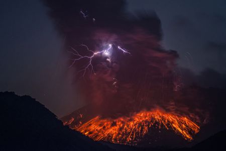
At 7 o'clock. 50 minutes Mont Pele volcano burst into pieces - 4 strong explosions sounded, similar to cannon shots. They threw a black cloud from the main crater, which was pierced by flashes of lightning. But this was not the most dangerous release. It was the lateral emissions - those that from that time will be called "Pelei" - sent fire and sulfur at a hurricane speed down the mountainside directly to Saint-Pierre - one of the main ports of the island of Martinique.
Superheated volcanic gas, due to its high density and high speed of movement, floated above the ground itself, penetrated into all the cracks. A huge cloud covered the area complete destruction... The second zone of destruction extended for another 60 km2. This cloud, formed from super-hot steam and gases, weighed down with billions of hot ash particles, moving at a speed sufficient to carry rock debris and volcanic eruptions, had a temperature of 700-980 ° C and was able to melt glass. Mont Pele erupted once more - on May 20 - with almost the same force as on 8.
The volcano Mont Pele, scattered to pieces, destroyed Saint-Pierre along with its population. 36 thousand people died.
1902 October 24, Guatemala, Santa Maria volcano
The volcano Santa Maria is located in the western part of Guatemala, the height of 3762 m, during its eruption with volcanic ash and debris a layer 20 cm thick covered an area of \u200b\u200b323.75 thousand km2. An explosion of gigantic power was heard for 800 km - in Costa Rica, a whole mountainside soared upward, carrying with it everything that was on it, then giant blocks fell down the slope. 6 thousand people died.
The clouds formed after the eruption hung for weeks. Before dispersing, they rose to a height of up to 20 km. This eruption is considered the largest in the entire history of volcanic emissions into the atmosphere.
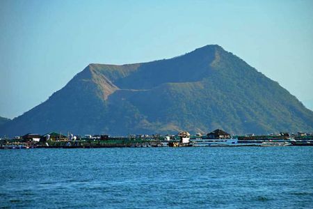
1911 January 30, Philippines, Taal volcano
During the most powerful eruption in the twentieth century, Taal, a permanent volcano in the Philippines, killed 1,335 people. It was a classic example of a "Peleus" type eruption, when the eruption occurs not only from the summit crater, but also from craters on the mountain slopes, often with hurricane force winds. In fact, the volcano does not emit lava, but masses of white hot ash and superheated steam.
In 10 minutes. all living things ceased to exist. A layer of mud up to 80 m thick, accompanied by a stream of poisonous volcanic gases, destroyed people and houses at a distance of 10 km. Gradually, ash covered an area of \u200b\u200balmost 2 thousand km2.
The mountain exploded a second time with almost the same force as in the first eruption. The crash was heard at a distance of almost 500 km. A black cloud of ash rose up, eclipsing the sky over Manila, located 65 km from the volcano. The cloud was seen from a distance of 400 km.
Taal remained calm until 1965, when another eruption occurred, killing 200 people. Until now, it remains an active and dangerous volcano.
1931 December 13-28, Indonesia, about. Java, Merapi volcano
One of the strongest volcanic eruptions XX century. Both slopes of the volcano exploded, and erupted volcanic ash covered half of the island. For two weeks - from 13 to 28 December, the volcano erupted a lava flow about 7 km long, up to 180 m wide and up to 30 m deep. The white-hot stream burned out the earth and destroyed all villages on its way. More than 1,300 people died.
1944 June, Mexico, Paricutin volcano
Parikutin is a volcano that was described in many magazines in 1943 as "a volcano born in a cornfield in front of its owner."
He really went up in a cornfield. For many years there was a small hole in this place; on February 5, 1943, a series of constantly intensifying tremors began, as a result of which a crack appeared near the hole. On February 19, residents felt at least 300 aftershocks. On February 20, the crack on one side of the hole began to widen. Almost immediately, there was a sound like thunder. Trees shook nearby, and the ground swelled by about a meter. Here and there smoke began to rise from the crack, and fine ash-gray dust. On February 21, lava began pouring out of the growing cone. By the end of the first week, the cone was 15 m high; by the end of the first year, it had grown to 300 m. In June 1944, a strong eruption took place. A huge lava flow descended towards the village of Paricutin and the larger village of San Juan de Parangaricutiro. Dense ash partially covered both settlements, there were several casualties.
1951 January 21, New Guinea, Lamington volcano
The eruption of Lamington volcano killed 2,942 people. Many of them died from hurricane winds filled with steam, hot ash, debris and hot mud. These hurricane winds were called "New Ardente" and manifested themselves during the eruption of Mont Pele volcano in 1902.
The Lamington eruption in New Guinea on January 21 was exactly the same type as Mont Pele, with New Ardentes sweeping away everything in its path as it descended the slope of the volcano. A series of monstrous explosions tore the summit and the slopes, throwing out a huge mushroom-shaped cloud of ash, which in 2 minutes. rose to a height of 12 km, and after 20 minutes. reached a height of 15 km. The explosion was so strong that it was heard on the coast of New Britain - 320 km from Lamington. Bursting out of the mountainside, the New Ardentes rushed down, sweeping away the forests so that not even stumps remained.
After another catastrophic outburst at 20:00. 40 minutes Mount Lamington ceased visible activity on January 21. Within 15 years, the vegetation returned to normal, but the slopes are not inhabited to this day.
1956 March 30, USSR, Kamchatka, Bezymyanny volcano
The violent explosion of the Bezymyanny volcano on the Kamchatka Peninsula largely went unnoticed, since there were no fatalities. However, in terms of intensity, it is on a par with the "Pelei" eruptions.
March 30 at 5 p.m. 10 min. The explosion of a monstrous force split the top of the Bezymyanny covered with snow, which had previously risen to an altitude of 3048 m above sea level. In a matter of seconds, 183 m peaks were chopped off from the volcano, and volcanic dust rose from the crater to a height of 30–40 km.
Volcanologist G.O. Gorshkov, who was located nearby in the village of Klyuchi, described this scene as follows: “The cloud swirled strongly and quickly changed its shape ... It seemed very dense and almost palpably heavy. A rumble of thunder arose and intensified along with the cloud, accompanied by incessant flashes of lightning. hour 40 minutes, when the cloud had already passed the zenith, ash began to fall out ... and by 6.20 minutes it became so dark that it was impossible to see his own hand, even if he brought it to his face. , wandered around the village in search of their homes. Thunder rumbled with deafening force, without stopping. The air was saturated with electricity, telephones spontaneously rang, loudspeakers in the radio network burned out ... There was a strong smell of sulfur. "
A hot layer of ash, covering an area of \u200b\u200b482 km2, melted the snow and formed rapid mud flows in the Sukhaya Khapitsa River valley and the valleys located on the slopes of adjacent volcanoes. These streams washed away huge boulders weighing hundreds of tons and carried them across the valley, sweeping away everything in their path. The trees were uprooted or burned. 3 weeks after the eruption, G.O. Gorshkov discovered thousands of jets of fumarole gases rising from the surface of a 30-meter layer of ash over an area of \u200b\u200b47 km2.
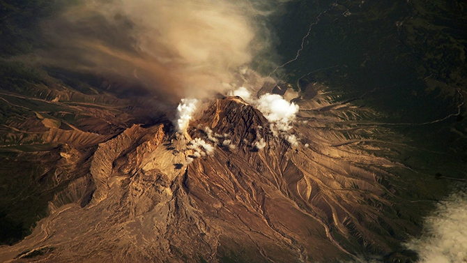
1980 May 18, USA, Washington State, St. Helens Volcano
A cloud of ash that shot up from the cone vertically upward in 10 minutes, rose to a height of 19.2 km. Day turned into night. In Spokane, Washington, 400 km from the volcano, visibility dropped to 3 m in broad daylight as soon as the cloud reached the city. In Yakima, 145 km from the volcano, a layer of ash fell up to 12 cm thick. A lesser amount of ash fell in Idaho, in central Montana and partly in Colorado. The ash cloud circled the globe in 11 days. For several weeks, a belt of ash colored sunsets and influenced the atmosphere. As in most eruptions, a lava dome with a height of 183 m and a diameter of 610 m was formed. Lava began to pour out of it. Throughout 1982, Volcano St. Helens erupted again, but with less force.
The energy released by the catastrophic explosion of the volcano corresponded to the energy of 500 atomic bombs such as those dropped on Hiroshima, or 10 million tons of TNT. An area of \u200b\u200b600 km2 burned down to the state of the lunar landscape.
Mount St Helens shrank like a broken tooth. The once symmetrical and well-built peak disappeared, and instead an amphitheater appeared 400 m below it with 600-meter sheer walls, with barren terrain below them.
1982 March 29, Mexico, El Chichon volcano
The eruption of the El Chichon volcano took place in two stages: March 29 and April 3-4, 1982. Initially, volcanic ash filled the atmosphere to an altitude of about 30 km. Then what happened to be in the stratosphere (about 10 Mt) began to be transferred to the west. The tropospheric part of the cloud (3–7 Mt) moved in the opposite direction and rather quickly settled on the Earth's surface. The stratospheric cloud, expanding horizontally, made several distinct revolutions around the Earth. Observations on the Hawaiian Islands showed that by December (compared to June), due to scattering, the ash concentration at an altitude of 20 km decreased by 6 times. In temperate latitudes, volcanic ash appeared in November 1982. Signs of increased turbidity in the Arctic stratosphere appeared only in March 1983. Thus, it took about a year for the pollution to be evenly distributed in the stratosphere of the Northern Hemisphere. Subsequently, it evenly decreased over the year by about 3 times.
1985 November 14-16, Colombia, Nevado del Ruiz volcano
The largest eruption of the volcano Nevado del Ruiz occurred in terms of the number of victims and material damage. A column of ash and rock debris rose to a height of 8 km into the sky. The hot gases thrown out of the volcano's mouth and the pouring out lava melted the snow and ice at its top. The resulting mudflow completely destroyed the city of Amero, located 50 km from the volcano. The layer of mud reached 8 m in places. The volcano practically destroyed everything around within a radius of 150 km. About 25 thousand people died, the total number of victims exceeded 200 thousand.
1991 June 10-15, Philippines, Luzon Island, Pinatubo volcano
Approximately 200 people died and 100 thousand were left homeless as a result of numerous eruptions.
On June 10, there was an eruption of the average force of Mount Pinatubo, located on the island of Luzon, 88 km from Manila. June 12 at 8 a.m. 41 minutes the volcano exploded, throwing a mushroom cloud into the sky. Streams of gas, ash and rocks molten to a temperature of 980 ° C poured down the slopes at a speed of up to 100 km / h. For many kilometers around, all the way to Manila, day turned into night. And the cloud and the ash falling out of it reached Singapore, which is 2.4 thousand km away from the volcano.
On the night of June 12 and in the morning of June 13, the volcano erupted again. And even more forcefully than before. He threw ash and flames into the air for 24 km.
On the morning of June 14, a typhoon hit the eastern coast of Luzon with a wind speed of 130 km / h, which flooded the area, soaked a layer of ash and turned it into white mud.
The volcano continued to erupt on June 15 and 16. Mud streams and water washed away the houses. A layer of ash 20 cm thick, turning into mud, destroyed buildings before our eyes. The slopes of Mount Pinatubo resembled lunar landscape... In the province of Zambales, the most affected region, everything was covered with a 90-centimeter layer of ash and volcanic debris.
The smallest particles of the ejected ash formed a huge cloud that encircled the entire globe along the equator. It contained little ozone in its central part, and a lot of sulfur dioxide along the edges. During the eruption, more than 20 million tons of sulfur dioxide were released into the atmosphere. The ash cloud of volcano Pinatubo, like volcano Krakatoa in 1883, led to some general decrease in temperature, as ash particles form a screen that traps sunlight. The presence of chlorine compounds and some other harmful gases in the atmosphere in a concentration higher than usual was recorded from space satellites.
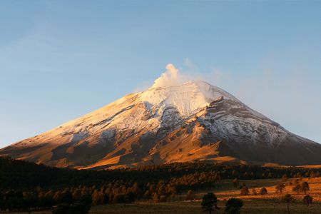
1997 June 30, Mexico, Popocatepetl volcano
There was a strong eruption of the Popocatepetl volcano, located 60 km from the capital of Mexico. The column of flame from the crater of the volcano reached 18 km in height, ash fell on the streets of Mexico City. Almost 40 thousand people were removed from the villages located near the mountain.
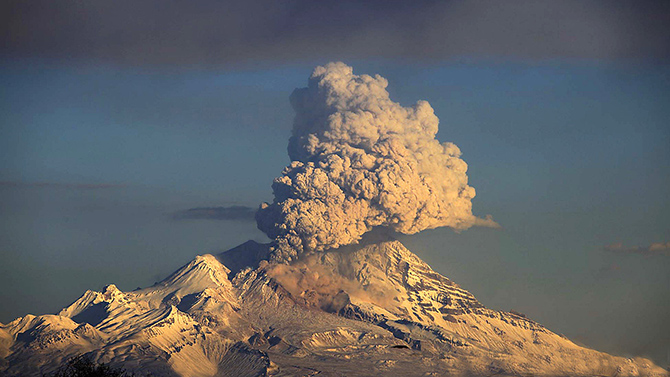
2000 March 14, Russia, Kamchatka, Bezymyanny volcano
During the eruption of the volcano, ash was thrown out with tremendous force to a height of 5 km above sea level, and the plume of ash clouds stretched in the northwest direction for at least 100 km. The village of Kozyrevsk, located at the foot of the volcano, was almost completely covered with ash, and the smell of sulfur was felt. The last time Bezymyanny erupted was on February 24, 1999, then ash emissions reached a height of 8 km. A similar ashfall was recorded on this volcano only in 1956. The awakened volcano did not pose any danger to the population.
2000 December, Mexico, Popocatepetl volcano
On December 14, the eruption of the Popocatepetl volcano began, it spewed hot stones and ash to a height of 1 km, the radius of their fall was about 10 km. 14 thousand people were evacuated. According to the authorities, the evacuation was announced mainly as a precaution - the ash from the volcanic eruption, which locals call El Popo, was blown away by the wind within a radius of more than 80 km.
On the night of December 18-19, there was a strong volcanic eruption. Stones, gas and a column of hot lava emanating from the crater located at an altitude of 5.5 km could be observed from anywhere in Mexico City, located 60 km away. From the vicinity of the volcano, 40 thousand people were urgently evacuated.
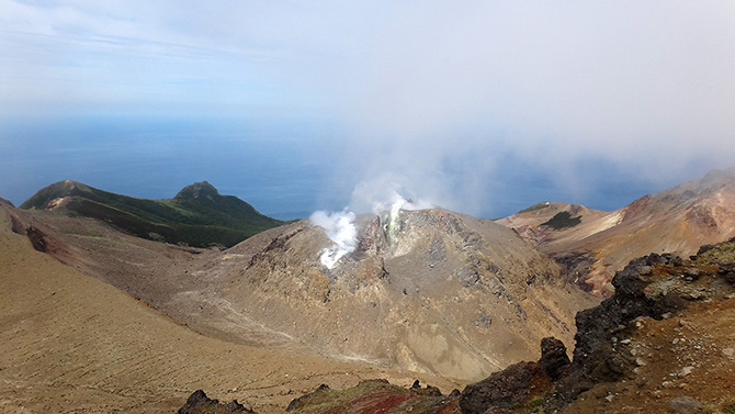
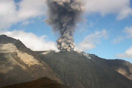
There are about two hundred different volcanoes in our country. Most are located on the territory of Kamchatka and the Kuril Islands, and they include 8.3% of the total number of active volcanoes on the planet. Here are 10 of them that have erupted over the past 10 years.
Berga Volcano (Last eruption: 2005).
it active volcano, located on the Urup island, in the middle of the Great ridge of the Kuril Islands. It is part of the Bell mountain group. The absolute height is 1040 m. The history of the Berg eruptions in 1946, 1951, 1952, 1970, 1973 and 2005 is known and recorded. Currently, thermal and fumarolic activity is recorded on it. The flora and fauna of the volcano are rather scarce, alder bushes grow on its slopes, and cormorants and gulls nest.
Chikurachki (Last eruption: 2008).
A complex stratovolcano with a summit crater, formed 40 to 50 thousand years ago. Located at the northern end of the Karpinsky ridge. The absolute height is 1816 m. One of the most active volcanoes of the Kuril Islands. The eruptions of 1853 and 1986 were the strongest (Plinian type). Between eruptions, the volcano is in a state of weak fumarolic activity.
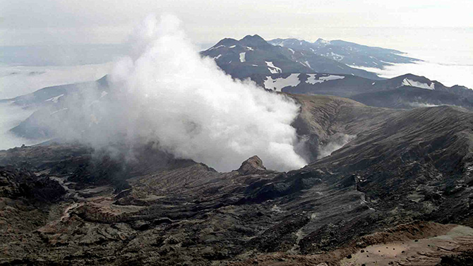
Sarychev volcano (Last eruption: 2009).
Somma-Vesuvius-type stratovolcano on Matua Island of the Greater Kuril Ridge; one of the most active volcanoes of the Kuril Islands. The absolute height is 1446 m. \u200b\u200bThe strongest volcanic activity took place from 12 to 15 June 2009. It manifested itself in the descent of pyroclastic flows, pyroclastic waves, and the outflow of lava flows. The pyroclastic flows reached the sea and in some places its coast retreated by 400 meters. These streams covered snowfields in the southeastern part of the volcano, which caused intense snow melting and, as a result, the descent of lahars. As a result of this eruption, the area of \u200b\u200bthe island increased by 1.5 square meters. km, and the surface of the volcano sank by 40 mm and shifted northward by about 30 mm. On an area of \u200b\u200bup to 30 sq. km the vegetation died.
Ebeko (Last eruption: 2010).
A complex stratovolcano with several summit craters. Located in the north of the island; in the northern part of the Vernadsky ridge. The absolute height is 1156 m. One of the most active volcanoes of the Kuril Islands. During the eruption in September 1859, thick sulfuric vapor covered the neighboring island of Shumshu, causing nausea and headaches in residents.
Plosky Tolbachik (Last eruption: 2012).
Tolbachik is a volcanic massif in the east of Kamchatka, in the southwestern part of the Klyuchevskaya group of volcanoes. It includes Ostry Tolbachik (3682 m) and Plosky Tolbachik (3140 m), located on the pedestal of an ancient shield volcano. New fissure eruption began on November 27, 2012 with the opening of a fissure about 5 km long a few kilometers south of the caldera. The lava flow of the South Center flooded the IVS FEB RAS station located at the foot of the volcano (the former Leningradskaya base), as well as the building of the Kamchatka Volcanoes natural park base.
Kizimen (Last eruption: 2013).
Located on the western slope of the southern end of the Tumrok ridge, 115 km from the village of Milkovo, 265 km from the city of Petropavlovsk-Kamchatsky. The absolute height is 2376 m. During the eruption in 2009, some geysers were activated in the valley of geysers. Before the eruption, there was an extrusive lava plug in the crater. On May 3, 2009 at 9:00 a.m. Kizimen became more active and the lava plug literally split into small volcanic rocks as a result, the ash scattered over most of the Kronotsky Biosphere Reserve.
Nameless (Last eruption: 2013).
A volcano in Kamchatka, near Klyuchevskaya Sopka, about 40 km from the village of Klyuchi, Ust-Kamchatsky District. The absolute height of this volcano is 2882 m. famous eruption The nameless happened in 1955-1956. The eruption cloud reached a height of about 35 km. As a result of the eruption, a horseshoe-shaped crater with a diameter of 1.3 km was formed, open to the east. At the eastern foot of the volcano on an area of \u200b\u200b500 sq. km trees and bushes were broken and felled away from the volcano.
Klyuchevskaya Sopka (Last eruption: 2013).
Stratovolcano in the east of Kamchatka. It is the highest active volcano on the Eurasian continent. The age of the volcano is approximately 7000 years, and its height varies from 4750 to 4850 m and more above sea level. The last eruption began on August 15, 2013. On August 26, the first lava flow was noted on the southwestern slope of the volcano, followed by 4 lava flows. On October 15-20, the culminating phase of the volcanic eruption was observed with an ash column rising up to 10-12 km. An ash plume stretched southwest of Klyuchevskoy volcano... In the villages of Lazo and Atlasovo, ash fell, the thickness of the falling ash is about two millimeters.

Karymskaya Sopka (Last eruption: 2014).
The volcano is located in Kamchatka, within the Eastern Ridge. Refers to stratovolcanoes. The absolute height is 1468 m. Very active volcano, since 1852 more than 20 eruptions have been recorded. Near Karymskaya Sopka, in the nearby caldera ancient volcano there is Karymskoe lake. In 1996, a powerful underwater explosion in the lake killed almost all living things.
Shiveluch (Last eruption: March 2015).
Volcano on the Kamchatka Peninsula within the Eastern Ridge. The northernmost active volcano in Kamchatka. The absolute height is 3307 m. On June 27, 2013, early in the morning, Shiveluch threw out a column of ash up to 10 km above sea level, in the village of Klyuchi located 47 km from the volcano, ash fell, the streets of the village were covered with a layer of red ash up to a millimeter thick. October 18 following the volcano Klyuchevskaya Sopka Shiveluch threw out a column of ash 7600 meters high. On February 7, 2014, he threw out a column of ash over 11,000 meters high. On May 13, 2014, the volcano threw out three columns of ash to a height of 7 to 10 km.
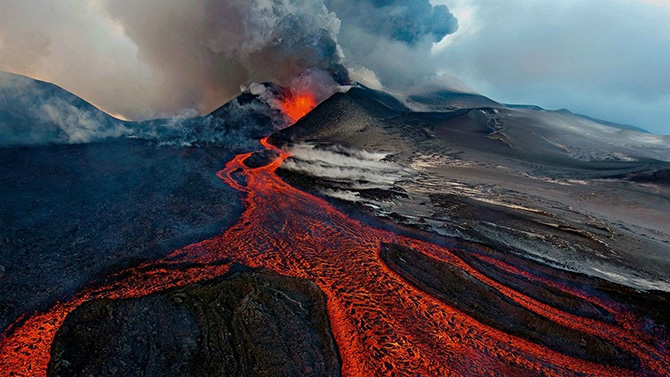
Volcano. This word fascinates and frightens at the same time. People have always been drawn to something beautiful and dangerous, because beauty, accompanied by risk, becomes even more attractive, but at the same time, the history of the city of Pompeii is immediately remembered. Volcanoes have not brought such terrible destruction for a long time, which is still stored in the pages of our history, because thanks to scientists who can tell which mountain is a volcano and which is not, people have stopped settling at the foot of dangerous mountains. But, nevertheless, volcanoes continue to exist and either go into hibernation or wake up from sleep in order to start active life. Let's take a look at which volcanoes are the largest in the world.
10 largest volcanoes in the world
- Volcano Yellowstone.This volcano is located in the Yellowstone national park in the USA. It is Yellowstone that can rightfully be called the most big volcano in the world, as well as the most dangerous volcano in the world. The height of the volcano is 3142 meters above sea level, and the area of \u200b\u200bthe volcano is 4000 square kilometers. The area of \u200b\u200bthis volcano is twenty times the size of Washington, the capital of the United States of America. This volcano is still dormant, although from the beginning of the twenty-first century it began to show signs of activity. According to scientists, this volcano erupts approximately every 600 thousand years, and since last eruption about 640 thousand years have passed.
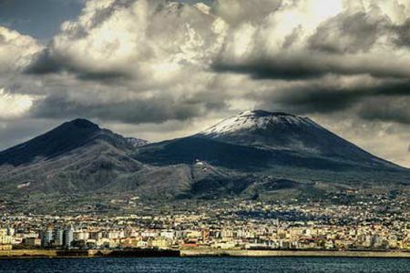
- Volcano Vesuvius.It is the highest active volcano in Eurasia at this time. And also he is the most high volcano in Europe. It is located fifteen kilometers from the Italian city. Its height is 1281 meters. Currently, Vesuvius is the only active volcano in Europe, and in addition, it is considered one of the most dangerous volcanoes... Science knows about more than eighty of its eruptions, one of which the famous ones were destroyed.
- Volcano Popocatepetl.This volcano is also active. It is located in southern Mexico. Popocateptl's height is 5452 meters. Over the past half century, its activity has been quite insignificant, and in general history knows about thirty-six major eruptions this volcano... Popocatepetl can be called the largest active volcano on this moment.
- Sakurajima volcano.An active volcano located in Japan. Once it was on the island, but during one of the eruptions, a huge amount of lava connected it to the mainland. The height of the volcano is 1118 meters above sea level. At the moment, many tourists visit Sakurajima every year, despite the fact that the volcano is almost constantly in activity - smoke escapes from its vents, and sometimes small eruptions occur.
- Volcano Galeras. This volcano is located in Colombia. The height of Galeras is 4267 meters above sea level. The activity of this volcano was noticed in 2006, at the same time people were evacuated from the nearest settlements. In 2010, more more people, since the volcano continues its active activity. Although over the past few thousand years, Galeras has erupted, if only very insignificantly.
- Volcano Merapi.An active Indonesian volcano located in Java. Height above sea level - 2914 meters. This volcano is active almost constantly. Small eruptions occur several times a year, and large ones approximately once every ten years. Merapi claimed many lives, and in one of his most large eruptionseven changed the surrounding landscape.
- Volcano Nyiragongo. This volcano is located in Africa, in the Virunga Mountains. At the moment, it is more in sleep mode, although little activity is sometimes observed. The most terrible eruption of this volcano was recorded in 1977. In general, this volcano is interesting in that its lava is very liquid because of its composition, therefore, during an eruption, its speed can even reach one hundred kilometers per hour.
- Volcano Ulavun. The volcano is located on an island New Guinea and at the moment it is an active volcano. Its height is 2334 meters above sea level. This volcano erupts quite often. Once this volcano was located under water, and it came to the surface only in 1878.
- Taal volcano.This active volcano is located in the Philippines, on the island of Luzon. Taal is notable for the fact that it is the smallest of all currently not dormant volcanoes in the world, and there is a lake in the Taal crater. Taal is visited by many tourists from all over the world every year.
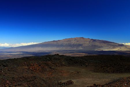
- Volcano Mauna Loa. Mauna Loa is an active volcano in Hawaii, USA. The height of this volcano is 4169 above sea level. This volcano can be considered the tallest volcano on earth if we take into account its underwater part, the height of which reaches 4,500 meters. Last time this volcano erupted seriously in 1950.
Today, September 14, 2013 marks exactly 5 years since the sudden activation of the Shiveluch volcano, which led to the partial destruction of its foundation. On this day, we tried to select the 10 largest volcanic eruptions, which were recorded and rated by a special scale - the Volcanic Explosive Index (VEI).
This scale was developed in the 80s, it includes a lot of factors, such as the volume of the eruption, speed, and others. The scale includes 8 levels, each of which is 10 times higher than the previous one, that is, a level 3 eruption is 10 times stronger than a level 2 eruption.
The last level 8 eruption took place on earth more than 10,000 years ago, but in the history of mankind there were still powerful emissions. We offer you the TOP of the 10 largest volcanic eruptions in the last 4000 years.
Huaynaputina, Peru, 1600, VEI 6
This volcano created the most major eruption in South America throughout the history of mankind. The instantaneous release instantly created several mudflows that headed towards the Pacific coast. Due to the ash thrown into the air, the summer in South America was one of the coldest in half a millennium. The eruption destroyed the nearby cities, which were restored only a century later.
Krakatoa, Sunda Strait, Indonesia, 1883, VEI 6
Throughout the summer, a powerful roar inside the mountain foreshadowed the eruption that occurred on April 26-27. During the eruption, the volcano threw out tons of ash, rocks and lava, the mountain was heard thousands of kilometers away. In addition, a sharp shock created a forty-meter wave, even on another continent, an increase in waves was recorded. The eruption killed 34,000 people.
Volcano Santa Maria, Guatemala 1902, VEI 6
The eruption of this volcano was one of the largest in the 20th century. A sharp jolt of a volcano sleeping for 500 years formed a crater 1.5 kilometers wide. The volcano claimed the lives of hundreds of people.
Novarupta Volcano, Alaska Peninsula, June 1912, VEI 6
This volcano is part of the Pacific Ring of Fire and its largest eruption in the 20th century. The powerful explosion sent 12.5 cubic kilometers of ash and magma into the air.
Mount Pinatubo, Luzon, Philippines, 1991, VEI 6
The eruption threw out so much ash that the roofs of nearby houses collapsed under its weight. In addition to ash, the volcano threw other substances into the air, which reduced the temperature of the planet by half a degree for a year.
Ambrim Island, Republic of Vanuatu, 50 AD, VEI 6 +
One of the largest eruptions in history occurred on this small island. To this day, this volcano remains one of the most active in the world. The eruption formed calderas 12 km wide.
Ilopango volcano, El Salvador, 450 AD, VEI 6 +
Although this mountain is only a few miles from the capital, San Salvador, it has created an incredible eruption in the past. It destroyed all Mayan settlements and covered a third of the country with ash. Trade routes were destroyed, and the entire civilization was forced to move to the lowlands. Now the crater houses one of the largest lakes in El Salvador.
Mount Thera, Greece, circa 1610 BC, VEI 7
Archaeologists believe that the force of the eruption of this volcano is comparable to that of several hundred nuclear bombs. If there were residents here, they either fled or died under force majeure. The volcano not only raised huge Tsunamis and lowered the planet's temperature with huge clouds of sulfur, but also changed the climate in general.
Changbai Volcano, border of China and Korea, 1000 AD, VEI 7
The eruption was so strong that ash was deposited even in northern Japan. Huge craters over a thousand years have turned into lakes that are popular with tourists. Scientists assume that still unexplored creatures live in the depths of the lakes.
Mount Tambora, Sumbawa Islands, Indonesia, 1815, VEI 7
The eruption of the Tambor volcano is the most powerful in the history of mankind. The mountain roared so loudly that it was heard 1200 miles away. In total, about 71,000 people died, and ash clouds covered many hundreds of kilometers around.
Related publications
-
 Features of men's diet for weight loss
The opinion that it is enough for a man to be a little more beautiful than a monkey has long ceased to be relevant. Currently, the strong half ...
-
 CANCER sun: Why is it dangerous to sunbathe Why sunny
The light of the Sun is one of the most important things on Earth. It supports life in every organism of our planet, and without it we simply would not ...