
Cosmic eruptions of volcanoes are forerunners of the earth

The harbinger of volcanic eruptions are volcanic earthquakes. Special instruments record changes in the inclination of the earth's surface near volcanoes. Before the eruption, the local magnetic field and the composition of volcanic gases change. In areas of active volcanism, special stations and points have been set up, in which continuous monitoring of volcanoes is conducted to warn them in time of their awakening. So, in Kamchatka in 1955, the volcanic Bezymyannyi volcano was predicted, in 1964 - Shiveluch volcano, then - Tolbachik volcanoes.
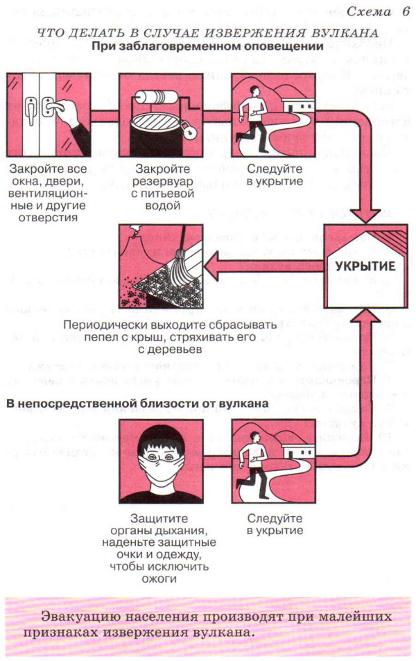
The only way to save people during eruptions of volcanoes is the evacuation of the population. The speed of the spread of lava is low, but it burns everything in its path. There is an intense release of volcanic ash, which impairs visibility, as well as hot stones. These stones destroy buildings, cause fires, terrify people.
The dangerous impact of relatively slow lava flows can be reduced in three ways:
Decline the flow;
divide it into several smaller ones;
stop by cooling, creating an earth wall, masonry, etc.
So, in 1960 during the eruption of the volcano Kilois, the foreman of the local fire department was jumped by the authorities for the decision to pour lava on the village. Meanwhile, the lava was cooled and frozen. After 13 years, in 1973, his brave example was followed by the Icelanders during the eruption of the volcano Kirchefeld. By feeding water from the sea to the lava stream, it was possible to stop the catastrophe.
It brings success and the division of the lava flow into several branches.
In 1935 on the Hawaiian Islands, a lava flow from the Mauna Loa volcano threatened the city. The bombardment of the stream from the aircraft was successfully carried out, the lava spread over the slopes and froze. The deadly stream that threatened the city was stopped in two days.
Sometimes bombardment is also used to destroy the crater wall and the direction of the lava flow in a safe direction.
An additional danger to people is the mud streams formed from the fallen rain and ash, moving at relatively high speeds. At the same time, one can be saved by sending such a stream to a safe direction, for example, in a reservoir.
Abundant fallout of ash is dangerous in that it accumulates in large quantities on the roofs of houses. In this case, it must be dropped downward.
The biggest danger is the "scorching cloud", from which you can escape only by flight.
It is necessary to remember that the forces of nature, concealed in volcanoes and other elements, are much larger than human ones. Nature must always be treated with respect.
The most reliable and safe way to protect yourself from a volcanic eruption is to choose a place of residence away from active volcanoes.
Since an earthquake occurs before the eruption of the volcano, all the rules of human behavior during it are actual in the case of a volcanic eruption.
Six of the most deadly volcanic eruptions
1. Vesuvius, 79 year of our era, killed at least 16 thousand people.
This eruption was known to historians from the letters of the eyewitness, poet Pliny the Younger to the ancient Roman historian Tatsiata. During the eruption, Vesuvius threw out a deadly cloud of ash and smoke at a height of 20.5 km, and also spewed about 1.5 million tons of molten rock and crushed pumice every second. At the same time, a huge amount of thermal energy was allocated, which many times exceeded the amount that was generated during the explosion of the atomic bomb over Hiroshima.
So, within 28 hours after the beginning of the eruption, the first series of pyroclastic flows (mixture of incandescent volcanic gases, ash and stones) descended. The currents overcame a huge distance, almost reaching the Roman city of Miseno. And then another series came down, and two pyroclastic flows destroyed the city of Pompeii. Subsequently, the cities of Oplontis and Herculaneum, located near Pompeii, were buried beneath volcanic sediments. Ashes also reached Egypt and Syria.
The famous eruption was preceded by an earthquake that began on February 5, 62. According to researchers, the earthquake was a magnitude from 5 to 6. It led to large-scale destruction around the Bay of Naples, where in particular the city of Pompeii was located. Damage to the city was so strong that they could not be eliminated even at the beginning of the eruption itself.
It is important to note that the Romans, as Pliny the Younger wrote, are used to periodic earthquakes in this region, so they were not particularly alarmed by this earthquake. However, since August 20, 79 earthquakes have become more frequent, but still not perceived by people as a warning of the impending catastrophe.
It is interesting that after 1944, Vesuvius is in a fairly calm state. However, scientists suggest that the longer a volcano is inactive, the stronger will be its next eruption.
2. Udzen, 1792, killed about 15 thousand people.
After the eruption took place in 1792, it remained inactive for 198 years, until the eruption that occurred in November 1990. Currently, the volcano is considered to be weakly active.
This volcano is part of the Japanese peninsula of Simabara, which is characterized by frequent volcanic activity. The oldest volcanic deposits in this region are over 6 million years old, and extensive eruptions occurred between 2.5 million and 500 thousand years ago.
However, the most deadly eruption occurred in 1792, when lava erupted from the volcanic dome of Fujin-deik. After the eruption, an earthquake followed, because of which the edge of the Mayu-Yam volcanic dome began to crumble, creating a landslide. In turn, the landslide provoked a tsunami, during which the waves reached 100 meters in height. Because of the tsunami killed about 15 thousand people.
According to the results of 2011, the magazine The Japan Times called this eruption the most horrible of all that ever happened in Japan. Also, the eruption of Unzen in 1792 is among the five most destructive eruptions in the history of mankind in terms of the number of human casualties.
3. Tambora, in 1815, killed at least 92 thousand people.
April 5, 1815, there was an eruption of the volcano Tambora, located on the Indonesian island of Sumbawa. It was accompanied by rumbling sounds that were heard even 1,400 km from the island. And on the morning of the next day volcanic ash began to fall from the sky and sounds resounding like the noise of guns firing in the distance. By the way, because of this similarity, a detachment of troops from Jogjakarta, an ancient city on the island of Java, thought that an attack had been committed on the neighboring post.
The eruption intensified on the evening of April 10: the lava began to flow, completely covering the volcano, and a "rain" of pumice with a diameter of up to 20 cm began. This was accompanied by the flow of pyroclastic flows from the volcano to the sea, which destroyed all the villages on its way.
This eruption is considered one of the largest in human history. During it, explosions were heard at 2600 km from the island, and the ashes reached at least 1300 km. In addition, the eruption of the Tambora volcano provoked a tsunami, during which the waves reached 4 meters in height. After the disaster, tens of thousands of inhabitants and animals of the island were killed, and all vegetation was destroyed.
It is important to note that during the eruption an enormous amount of sulfur dioxide gas (SO2) hit the stratosphere, which subsequently led to a global climatic anomaly. In the summer of 1816 extreme weather conditions were observed in the countries of the northern hemisphere, because of which the 1816th was named "The Year Without Summer". At that time, the average global temperature dropped by about 0.4-0.7 ° C, which is enough to cause significant problems in agriculture around the world.
So, June 4, 1816 in Connecticut, there were frosts, and the next day the majority of New England (a region in the northeastern United States) was covered by the cold. Two days later, snow fell in the cities of Albany, New York State and Dennisville, Maine. Moreover, such conditions lasted at least three months, because of which the majority of crops in North America died. Also, low temperatures and heavy rains led to a loss of yield in the UK and Ireland.
4. Krakatoa, 1883, killed about 36 thousand people.
Before the catastrophic eruption of the Indonesian volcano Krakatau in 1883 on May 20, the volcano began to produce a large amount of smoke and ash. This lasted until the end of the summer, when on August 27 a series of four explosions completely destroyed the island.
The explosions were so strong that they were heard at 4800 km from the volcano on the island of Rodriguez (Mauritius). According to the researchers, the shock wave from the last explosion spread around the world seven times! Ashes rose to a height of 80 km, and the sound of the eruption was so loud that if someone was 16 km from the volcano, he would certainly be deaf.
The emergence of pyroclastic flows and tsunamis had catastrophic consequences both in the region and throughout the world. According to the government, the death toll was 36,417, although some sources claim that at least 120,000 people died.
It is interesting that the average global temperature during the year after the eruption of Krakatoa has decreased by 1.2 ° C. To the former temperature returned only in 1888.
5. Mont-Pele, 1902, killed about 33 thousand people.
In April 1902, the awakening of the volcano Mont Pelay located in the north of the island of Martinique (France) began. And on the evening of May 8, an eruption suddenly began. A gas-ash cloud began to rise from the crack at the foot of Mont-Pele.
Soon a hurricane of hot gases and ash reached the Saint-Pierre, located 8 km from the volcano, and in a few minutes destroyed it and 17 steamships standing in its harbor. "Roddam", suffered multiple destruction and "powdered" with ashes, was the only ship that managed to get out of the bay. The strength of the hurricane can also be judged by the fact that the monument weighing several tons was thrown a few meters from its place in the city.
Arrivals, almost all the population and animals died during the eruption. Only two people survived by a miracle: prisoner of the local prison August Sibarus, who was sitting in an underground solitary cell, and lived on the outskirts of the town cobbler.
6. Nevado del Ruiz, 1985, more than 23 thousand people.
Since November 1984, geologists have observed an increase in the level of seismic activity near the volcano Nevada del Ruiz (Colombia), located in the Andes. And on the afternoon of November 13, 1985, this highest active volcano of the Andean volcanic belt began to erupt, throwing ash into the atmosphere to a height of more than 30 km. The volcano produced pyroclastic flows, under which melted ice and snow in the mountains - there were large lahars (mud volcanic flows). They descended down the slopes of the volcano, eroding the soil and destroying vegetation, and eventually fell into six river valleys leading from the volcano.
One of these lahars practically washed away the small town of Armero, which lay in the valley of the river Lagunilla. Only a quarter of its residents (a total of 28,700 people) survived. The second stream, which descended the valley of the Chinchin River, killed about 1800 people and destroyed about 400 houses in the city of the same name. In total, more than 23 thousand people were killed and about 5 thousand were injured.
The eruption of Nevado del Ruiz in 1902 is considered the most terrible natural disaster that occurred in Colombia. The death of people during his time was partly due to the fact that scientists did not know when the eruption would occur, because the last time it happened 140 years ago. And since it was not known about the imminent danger, the government did not take expensive measures.
QUESTIONS AND TASKS
1. What do you know from the history of volcanoes?
2. What are the volcanoes and what is their danger?
3. How does the volcano work?
4. What natural disaster accompanies the volcanic eruption?
5. Name and show on the map of our country active and extinct volcanoes.
6. Show on the map the main belts of volcanic activity.
7. What are the dangerous volcanic eruptions and their consequences?
8. List the main ways to reduce damage from volcanic eruptions.
9. What is the procedure for declaring a threat of a volcanic eruption?
10. Find out if it is possible in your locality to erupt a volcano, where it is, when there was a last eruption, whether there are extinct volcanoes.
The scientists made a unique discovery. The eruption of the volcano, which happened recently in Iceland, and was even more powerful than last year, coincided with the eruption of a volcano ... on Jupiter. Have such coincidences occurred before? And is it possible, when observing the volcanic activity on other planets of the solar system, to predict such events on our Earth?
On May 21, after seven years of rest, the active volcano Iceland. Within a short time, an enormous column of ash exploded into the atmosphere, the trail behind it subsequently stretched for 20 kilometers. Scientists report that other volcanoes are becoming active. If they all wake up from hibernation in the near future, the Earth will be in an extremely difficult situation.
At first glance this may seem delusional, but scientists believe that volcanic activity can be the cause of volcanic activity on Earth. The fact that somehow terrestrial volcanoes can be influenced by their relatives on other planets was established by Soviet astrophysicists back in the late 1980s. To this unexpected conclusion, scientists came during the observation of the satellite of Jupiter Io.
As it turned out, Io - the most restless heavenly body in the entire solar system. Every day, up to 10 volcanic eruptions are recorded on its surface. And this despite the fact that all of them on the surface of the satellite about 400. When the eruption up, huge columns of sulfur dioxide gas rise. It happens that the height of these emissions reaches 300 kilometers.
Long-term observations of Io showed that in those moments when Io starts to erupt the most large volcanoes, seismic activity also increases on the Earth. Part of this theory was confirmed in 2002, when on the satellite of Jupiter his very self began to erupt a powerful volcano Loki. This event was detected by an autonomous spacecraft operating in orbit of Io. The volcano's ejection was so powerful that it reached a 500-kilometer altitude, and the station, flying through this fountain of gas, managed to take samples. Chemical analysis made it possible to find out that Loki erupted from ash and lava. The most interesting was the fact that a few calendar months later a series of natural disasters occurred on our planet.
The summer of 2002 in Europe was marked by a severe flood. Usually at this time such natural phenomena are not observed, but this time in the Czech Republic, for example, the flood was the most devastating since 1500. Strongly affected by this phenomenon and neighboring countries - Austria, Germany, Romania, Hungary and Croatia. In the same 2002, the flood did not bypass Russia. Karachay-Cherkessia, Adygea, Stavropol and most of the Krasnodar Territory were under water. Storm rains in the anomalous amount caused significant damage. In particular, power lines, gas pipelines, and some communications were destroyed on the Black Sea coast. Thousands of families were affected by the flood, left homeless, the elements took with them more than a hundred human lives.
The second eruption of Loki was recorded at the end of 2004, and again scientists found a direct link to events on Earth scale. December 26 on the island of Sumatra in the northern part of it happened the most powerful earthquake with a magnitude of 9 points, which caused a fracture of the earth's crust for 600 kilometers. For this reason, tectonic plates on the bottom of the Indian Ocean began to move, which led to the emergence of the most powerful tsunami over the entire observation period. Waves up to twenty meters high hit the shores of Sri Lanka, India, Bangladesh, Thailand, Indonesia and even reached the coast of African Somalia, which is 5,000 kilometers from the epicenter of the earthquake.
The tragic earthquake in Japan, which occurred on March 11 of this year, led to the emergence of a powerful tsunami wave that claimed many lives. But a month before this event astronomers recorded another peak of activity of the Loki volcano on Io - the height of the fountain reached 400 km this time.
Scientists can not predict the activity of the Loki volcano in the future. To do this, Io needs to install a network of seismic sensors on the surface of the Io, this can help scientists learn more about volcanos of extraterrestrial origin, which in turn can prevent future catastrophes on our own planet.
Scientists firmly believe that such a network of sensors should be installed not only on Io, but also on our nearest neighbors - Venus and Mars, and even on our moon companion, where there are also volcanoes, although inactive. But they can wake up at any moment, which can be dangerous for the Earth.
The Institute, which monitors all volcanic eruptions, since the IXX century, cites data that indicate a steady increase in their number. The increase in volcanic activity is associated with an increase in activity of extraterrestrial volcanoes and it is already estimated that the peak will be in 2035. These events will trigger synchronous processes on our planet, scientists believe. Moreover, if our neighbors wake up the most large volcanoes, they will provoke the eruption of their terrestrial counterpart - a huge volcano Yellowstone. Its size amazes imagination - the edges of the volcano lie in three different states - Montana, Wyoming and Idaho. The last time the volcano erupted more than 600 thousand lei back, so it is considered asleep.
At that time, an event of this magnitude led to disastrous consequences. Clouds of smoke and ash for a long time overshadowed the sky over North America, which resulted in a small ice age, which provoked the death of thousands of species of flora and fauna. If such an event occurs again, the consequences will be the most sad for the Earth. Both American continents will simply disappear, large disasters are expected in the rest of the planet.
In any case, no one doubts that this will be the most powerful eruption of the volcano in the history of mankind. A huge explosion of power can wake most of the volcanoes on the planet, and with this scenario, no one will survive. Today there are about 600 volcanoes on the Earth, which are active. But a huge number of volcanoes are in the depths of the sea. For example, only in the central regions of the Pacific Ocean there are about two hundred thousand, however, most of them are inactive and are waiting for their time.
There remains only one hope - that scientists will learn first to predict these terrible phenomena in space, and then will find opportunities to fight them on Earth.
Based on tainy.net
Catastrophic eruptions of volcanoes are accompanied by large casualties among the population. During the eruption of the volc. Tambora in Indonesia in 1815 killed from 60 thousand to 90 thousand people. Explosion vkl. Krakatoa in 1883 caused the death of 40 thousand people. From the scorching clouds formed during the eruption of the volcano. Lamington in New Guinea, killing about 4 thousand people. The harbinger of the eruption are volcanic earthquakes, which are associated with the pulsation of magma moving upward along the supply channel. Special instruments - tiltmeters - record the change in the inclination of the earth's surface near volcanoes. Before the eruption, the local magnetic field and the composition of the volcanic gases released from the fumaroles change. In 1955 an eruption of volcano was predicted in Kamchatka. Untitled, in 1964 - vk. Shiveluch, then - Tolbachik volcanoes.
A number of volcanic stations operate on volcanic territories. As for earthquakes, maps are compiled volcanic hazard (risk). A detailed map of this kind was compiled for Kamchatka in the Russian Federation, for the Hawaiian Islands and the Cascade Mountains in the USA. In the Russian Federation, direct observation of volcanoes is carried out by the Institute of Volcanology of the Far Eastern Branch of the Russian Academy of Sciences.
The forecast of eruptions is based on two groups of methods. The first are based on the study of the life of the volcano itself: individual volcanoes erupt at certain intervals of time, their other awakening signify sound effects; knowledge of volcanoes can help in preventing eruptions. Another group of methods is made up of complex statistical calculations and studies of the signs of a forthcoming eruption with the help of precision instruments. Around dangerous volcanoes locate, as a rule, seismic stations recording jerks. When the lava expands at depth, filling the cracks, it causes a shaking of the earth's surface. Earthquakes with foci of volcanoes are, therefore, a reliable sign of a forthcoming eruption.
Reliable is the method of forecasting volcanic eruptions based on measuring changes in the slopes of the earth's surface near the volcano. The change in slope indicates that an eruption is being prepared. By the rate of increase of changes, it is possible to calculate the approximate time of the eruption.
A new method of prediction of eruptions is the aerial photography of volcanoes in infrared rays, and it allows to determine the heating of the earth's surface and the rise of hot melts.
The behavior of water in the crater can also serve as a reliable indicator of the impending eruption. Sometimes the water temperature rises to a boil, sometimes it changes its color before the eruption (it becomes brown or reddish). Before the eruption, the concentration of sulfur-containing gases and hydrochloric acid vapors often increases, while the percentages of water vapor decrease and the S / Cl ratio increases.
The method of studying the change in the magnetic field can also justify itself: in Kamchatka in 1966, 12 hours before the eruption, the intensity of the magnetic field weakened, and a few months before the eruption, its orientation also changed.
A successful prediction of volcanic eruptions can significantly reduce the volcanic risk for the population. Petropavlovsk-Kamchatsky, Yelizovo, Klyuchi, Severo-Kurilsk and other settlements, as well as for the passengers of hundreds of international flights daily along the eastern coast of Kamchatka.
From a practical standpoint, short-term, medium-term and long-term forecasts of volcanic activity are highlighted.
Short-term forecast - the most accurate. The conclusion about the time of the forthcoming eruption is made on the basis of the totality of the results of all methods. The physical basis of the forecast is a gradual and continuous increase in the pressure in the magmatic focus and the outlet channel of the volcano before the eruption. The increase in pressure in the outlet channel causes stresses and elastic deformations in the surrounding solid rocks, a change in their physical properties, which is reflected in the physical field in the volcano region. The establishment of regularities in the connection of changes in the physical field of a volcano with its activity and continuous monitoring of these changes constitute the essence of a short-term forecast of eruptions. The characteristic phenomena that precede eruptions include: deformation of the earth's surface, volcanic earthquakes (Figure 2.4); changes in gravitational, magnetic and electric fields in the vicinity of the volcano; warming up the volcano; change in temperature and chemical composition of fumarolic gases and waters of hot springs. The most promising are methods based on observations of volcanic earthquakes, deformations of the earth's surface and hydro-chemical phenomena on volcanoes. Since the 1980s, aerial photogrammetric methods for predicting volcanic eruptions have been developing in Kamchatka.
Long-term forecast can be performed with sufficient accuracy only for those volcanoes in whose activities there is a periodicity. For the rest of the volcanoes, this forecast is not accurate, but only allows you to establish cause-effect relationships in tectonic activity in a particular area. On the basis of such calculations it is possible to obtain probability characteristics that are important data for the short- and medium-term forecasts.
Introduction
1 . Volcanoes of the Russian Federation
2 . Classification of volcanoes in form
3 . Volcanic eruptions
4 . Signs of an impending eruption
5 . Actions of people in the eruption of the volcano
6 . Other threats associated with the deposition of volcanic sediments
Conclusion
Information sources
Introduction
Outwardly, each volcano is an exaltation, not necessarily high. The elevation is connected by a channel with a magmatic focus at a depth. Magma is a mass of mass, consisting mainly of silicates. Magma, obeying certain physical laws, can rise together with water vapor and gases from the depths upward. Overcoming obstacles in its path, magma pours to the surface. Magma, spilled on the surface, called lava. The discharge from the vole of the volcano vapor, gases, magma, rocks and there is an eruption of the volcano.
The main parts of the volcanic apparatus:
Magmatic focus (in the earth's crust or upper mantle);
The vent is the outlet channel through which magma rises to the surface;
The cone is an elevation on the surface of the Earth from the products of the volcano ejection;
The crater is a depression on the surface of the cone of a volcano.
More than 200 million earthlings live in dangerous proximity to active volcanoes. Of course, they are exposed to a certain danger, but the degree of risk does not exceed the possibility of getting under the car of a city dweller. It is estimated that about 200 thousand people died in the world as a result of volcanic eruptions in the last 500 years.
There are about 600 active volcanoes on the earth. The highest of them are in Ecuador (Cotopaxi - 5896 m and Sangay - 5410 m) and in Mexico (Popocatepetl - 5452 m). In Russia there is the fourth highest volcano in the world - this is Klyuchevskaya Sopka the height of 4750 m.
The most catastrophic can be considered generally low - 800 m - Indonesian volcano Krakatau. At night, from August 26 to August 27, 1883, after three terrible explosions on a small deserted island, the sky covered ash and 18 cu. kilometers of lava. A huge wave (about 35 m) literally washed away hundreds of coastal towns and cities of Java and Sumatra. In this tragedy killed 36 thousand people. volcano eruption
1. Volcanoes of the Russian Federation
The current volcanic activity on the territory of the Russian Federation is almost entirely concentrated in the Kuril-Kamchatka island arc, where there are at least 69 active volcanoes. At the same time, potentially active or "sleeping" volcanoes are found in several other regions of the country. First of all, it is the Great Caucasus with the volcanoes of Elbrus and Kazbek (the last eruptions within 3-7 thousand years ago), the south of Eastern Siberia (the Kropotkin volcano, active 500-1000 BP), Chukotka (Anyui volcano, operating in limits of the last millennium) and, possibly, the Baikal region.
Kamchatka and the Kuriles are a seismically unstable region that is part of the "ring of fire" of the Pacific Ocean. Of the 120 volcanoes that are located here, about 39 active - from the depths here you can wait and strong eruptions, and earthquakes.
In 1955 there was an eruption of the hills of Bezymyannaya. In November, the volcano woke up and began to throw away fumes and ash. November 17 in the village of Klyuchi (24 km from the hill) it was so dark that the whole day did not turn off the electricity.
March 30, 1956 the volcano Nameless exploded. From the crater to an altitude of 24 km, a cloud of ash rose. In the next 15 minutes, an even larger cloud was erupted to a height of 43 km. At 24 km from the crater, the trees were torn from the ground, in 30 km - fires occurred, mud flows stretched for 90 km. The resulting wave was felt at a distance of up to 20 km from the crater.
After the eruption, the shape of the volcano completely changed, and its peak became lower by 500 m. A funnel with a width of up to 2 km and a depth of 1 km was formed at the site of its summit.
In 1994, when the volcano Klyuchevskaya Sopka erupted, the ash cloud complicated the flights of aircraft at an altitude of 20,000 meters.
Almost all manifestations of volcanic activity are dangerous. Lava and mud flows (lahars) can completely destroy the settlements that lie in their path.
Danger threatens people who are near or between the languages of magma. No less terrible is ashes, penetrating literally everywhere. Sources of water are littered with lava and ash, the roofs of houses collapsed.
The volcano is dangerous not only during the eruption. Crater can still conceal boiling sulfur under externally strong bark for a long time. Dangerous and acidic or alkaline gases, which resemble fog.
The valley of death in Kamchatka (in the Valley of Geysers) accumulates carbon dioxide, which is heavier than air, and animals often die in this lowland.
2. Classification of volcanoes in form
-Thyroid volcanoes are formed as a result of multiple releases of liquid lava. This form is typical for volcanoes erupting basalt lava of low viscosity: it flows from both the central crater and the slopes of the volcano. The lava spreads evenly over many kilometers. As, for example, on the Mauna Loa volcano in the Hawaiian Islands where it flows directly into the ocean.
-Slag cones throw out from their vents only such loose substances as stones and ashes: the largest fragments accumulate in layers around the crater. Because of this, the volcano with every eruption is getting higher. Light particles fly away to a further distance, which makes the slopes flat.
-Stratovolcanoes, or "layered volcanoes," periodically erupt lava and pyroclastic material - a mixture of hot gas, ash and red-hot stones. Therefore, deposits on their cone alternate. On the slopes of stratovolcano, ribbed corridors are formed from frozen lava, which serve as a support for the volcano.
-Dome volcanoes Formed when a granite, viscous magma rises above the edges of the crater of the volcano and only a small amount seeps out, draining along the slopes. Magma clogs the vent of the volcano, like a cork, which the gases accumulated under the dome literally kick out of the vents.
3. Volcanic eruptions
Volcanic eruptions are geological emergencies that can lead to natural disasters. The eruption process can last from several hours to many years. Among the various classifications, general types are distinguished:
Hawaiian type - emissions of liquid basaltic lava, lava lakes are often formed. should resemble scorching clouds or incandescent avalanches.
Hydroexplosive type- eruptions occurring in the shallow waters of the oceans and seas are distinguished by their formation a large number of Steam generated by the contact of hot magma and seawater.
4. Signs of an impending eruption
- Strengthening seismic activity (from subtle fluctuations in lava to a real earthquake).
- "Grumbling", coming from the crater of the volcano and from under the earth.
- The smell of sulfur, coming from the rivers and streams flowing near the volcano.
- Acid rainfall.
- Pumice dust in the air.
Classification of volcanoes is made according to the conditions of their origin and the nature of volcanic activity.
The first feature distinguishes the four types of volcanoes.
Type 1 - volcanoes in subduction zones. The upper layers of the Earth behave as solid, fitted plates to each other, which sit on the body of the Earth and are able to move: move apart, slide or slide one against the other. There is a mixture of main plates that run along the mid-ocean ridges, intersecting almost each of the oceans, and along the active edges of the continents, coinciding with the seismic activity belts. At the mid-ocean ridges, due to thermal convection, the plates move apart, and on their borders accumulate lava, which brings upward convective currents. In this case, the oceanic bottom is dragged down, forming an underwater cavity, and the continental material, consisting of lighter rocks, is not submerged, but is pushed over the oceanic plate. A zone of subduction or zone of feat of an oceanic plate under the continental zone is formed. The magma accumulated at the boundaries of the continental plates rushes to the earth's surface, which leads to volcanic eruptions and the formation of volcanoes.
2nd type -volcanoes in rift zones, - zones arising in connection with the weakening of the earth's crust and the bulging of the boundary between the crust and the mantle of the Earth. Rift zones are formed in the mid-oceanic ridges. The characteristic rift zones include the East African rift valley, Iceland, part of the Azores and several other islands of the Atlantic Ocean. The formation of volcanoes in these zones is associated with tectonic phenomena occurring during the buckling of the Earth's crust.
3rd type -volcanoes in the zones of large faults. In many places of the earth's crust there are discontinuities. When the rocks on both sides of the rupture are displaced so much that its individual layers do not correspond to each other, the rupture of the earth's crust passes into a fault. Such faults can occur both on continents and at the bottom of the oceans. In the fault areas there is a slow accumulation of tectonic forces, which can turn into a sudden seismic explosion with volcanic manifestations. This group includes volcanoes of Central America, the Caribbean, most of the Azores, the Canary Islands and the Cape Verde Islands.
4th type- volcanoes of zones of "hot spots". In some areas, under the ocean floor, "hot spots" are formed in the earth's crust, where particularly high thermal energy is concentrated (for example, because of the high concentration of radioactive substances). In these zones, rocks are melted and, in the form of basalt lava, emerge on the surface of the ocean floor, as a result of which volcanic manifestations are observed.
According to the type of volcanic activity, there are five main types of volcanoes (Table 2.15).
Table 2.15
Main types of volcanoes
End of Table. 2.15
|
Type of volcano |
The main signs of eruption |
|
The volcano with a central dome. Viscous lavas clog the supply channel. From time to time, the crater breaks through the pressure of the gases. Eruption and ejection of tephra occur. After exploding lava flows calmly |
|
|
From a deep magmatic focus, a lava saturated with gases is poured out onto the earth's surface. Strong explosions, it is released into the atmosphere to a height of several kilometers and falls in the form of ash. The activity is episodic, long periods of rest are observed |
|
|
Very viscous lava clogs the supply channel and forms a volcanic column. To the foot of the volcano falls a scorching cloud |
Volcanoes of Kamchatka and the Kuril Islands have a number of features inherent in the first, second and fourth types of volcanoes. In connection with volcanic activity, it is necessary to note such phenomena as hot or thermal springs and geysers.Mineral and fresh hot springs are common in areas of modern or very recent volcanism, for example in Iceland, Italy, the Hawaiian Islands, the Caucasus, Kamchatka and many other areas. Atmospheric waters, penetrating into the depth, are heated by the internal heat of the volcano, mixed with volcanic gases and come to the surface in the form of mineral springs. Around such sources arise fancy growths of silicon or calcareous tuff - the so-called travertines. So, on the slope of Mashuk Mountain near the city of Pyatigorsk, in the area of Caucasian Mineral Waters, there are travertines enveloping leaves of plants and bones of ancient animals, as mineral springs have been pouring there for hundreds of thousands of years.
In places where there are modern volcanoes or their eruptions, there are periodically gushing springs - geysers. This name came from Iceland, where in the XVIII century. The Great or Great Geyser operated - a powerful hot flowing source in which water boiled every 30 minutes and the jet was thrown upward to a height of 60-65 m. Currently, geysers exist in Yellowstone National Park in the west of the USA, in New Zealand, Iceland and on Kamchatka, where the famous Valley of Geysers is located. In the lower reaches of this unique beauty valley for 5 km there are many geysers, boiling and pulsating springs, as well as mud boilers and steam jets. Some geysers, for example, such as Pervenets, spout 10-15 minutes to a height of 15 m, and the Geyser Giant - to a height of 30 m, with the pole of the steam reaching 100-120 m. As in the valley of the Pauzhetka River in the south of Kamchatka, here are widespread boiling mud boilers, on the surface of which continuously gurgles mud, swelling with large bubbles. When the geyser is young, the spacing between the gushing is small. Over time, they become more and more, the water pressure decreases, and finally the geyser dies. The main "propulsor" of this "system" is volcanic heat and gases.
Modern areas of volcanic activity contain a huge supply of geothermal energy, including overheated to several hundred degrees of water vapor, which can be used to generate electricity, heat houses, greenhouses, etc. This is done in Iceland, New Zealand, Italy, Russia in Kamchatka) and other places. In the south of the Kamchatka Peninsula in the area of the Pauzhetka River, a geothermal power plant with a capacity of 5,000 kW is built, operating on an overheated volcanic steam. The greatest difficulty in using volcanic heat is the aggressive nature of boiling water containing acids, and steam, which quickly corrode metal pipes and machine parts. This makes it necessary to heat with natural steam first the usual clean fresh water and only then let steam into the turbines.
Publications on the topic
-
 Download game Akinator via torrent russian version
Title: Akinator Genre: Twenty Questions (On-line game) Country: France. Developer: Arno Megre, Jeff Del Publisher: Gun Media Game ...
-
 Spider description of an insect for children
SPIDERS (Aranei), a group of arachnids, including mites, scorpions, haymakers, etc. Spiders are close to ...