
Basic concepts of earthquake science. Earthquake as a geophysical process. Basic concepts of seismology. Assessment of intensity in points - Nature and control of earthquakes

\u003e Earthquake as a geophysical process. Basic concepts of seismology. Assessment of intensity in points
The science of earthquakes, seismology, although young, has made serious progress in understanding the object of its research. The names of A.P. Orlova, I.V. Mushketov, K.I. Bogdanovich, V.N. Weber, B.B. Golitsyn, G. A. Gamburtseva, S.V. Medvedeva, Yu.V. Riznichenko - bright reference points on the growth curve of domestic and world seismology.
By the efforts of several generations of researchers, experts now have a good idea of what happens during an earthquake and how it manifests on the surface of the Earth. But after all, surface phenomena are the result of what happens in the bowels. And the main focus of specialists is now focused on understanding the deep processes in the bowels of the Earth, the processes leading to the earthquake, its accompanying and following.
The theory of earthquakes as a geophysical process is only being developed. Although this kind of research is now widely used physical and mathematical modeling, the knowledge of various natural phenomena associated with earthquakes is largely based on observations on the earth's surface.
Scientific geology (its formation dates back to the eighteenth century) has drawn the right conclusions about the fact that the youngest sections of the earth's crust are shaken. In the second half of the nineteenth century. a general theory has already been chosen, according to which the earth's crust was divided into ancient stable shields and young, mobile mountain structures. It turned out that the young mountain systems - the Alps, the Pyrenees, the Carpathians, the Himalayas, the Andes - are subject to a strong earthquake, while the ancient shields (to which the Czech Massif belongs) are areas where strong earthquakes are absent.
Among the most common seismological terms associated with the concept of "earthquake", include the following: the hearth, hypocentre, epicenter, magnitude, score.
Under the focus of the tectonic earthquake is understood the closed volume of terrestrial matter, in which a short enough time, up to 1-3 minutes, occurred destruction. As a rule, in the region of the focus there is a shift (shift) of one part of the volume relative to the other. The place where the shift begins is called the hypocentre.
It is from this point that the generation of seismic waves begins, which can lead to destruction outside the hearth. The projection of the hypocentre vertically on the earth's surface was called the epicenter.
The concept of a score characterizes the intensity of the shock at the observation point. In our country since 1964 the 12-point scale MSK-64 is used. It should be noted that non-seismologists in points often characterize the very strength of an earthquake in the hearth. This is not true, but it occurs regularly in newspaper reports. As a rule, this applies to the Richter scale, which uses the dimensionless magnitude M of the earthquake, which is proportional to the logarithm of the energy released in the source. Confusion arose in connection with two circumstances: 1) the magnitude of the earthquakes known so far does not exceed 9 units (in catalogs there is only M (max.) Is 8.9), that is, the magnitude is numerically close to the values of the concussion points; 2) we are used to the fact that any parameter has a dimension (meters, kilograms, degrees), and after all the logarithms of any parameters are always dimensionless. Therefore, if there are reports in the press such as "the earthquake had 7 points on the Richter scale," then in reality this means that the earthquake magnitude is M = 7. And it can be felt in different points by force 10 points, 8 points, 5 points, this depends on the distance to the hearth. Thus, if the glossiness depends on the distance to the source, then the magnitude does not depend.
The MSK-64 scale was compiled for buildings and structures that do not have earthquake-resistant reinforcement structures. I will give here the description of the first four points of this scale without changes, and starting with the fifth, when damage to buildings is possible, I will describe the main distinguishing features of earthquakes and their likely impact on the buildings of modern buildings in Kamchatka. When describing each point in parentheses, the frequency of occurrence of earthquakes of a given strength for Petropavlovsk-Kamchatsky is indicated.
1 b a l. An impassable earthquake. The intensity of the oscillations lies below the sensitivity limit, ground tremors are detected and recorded only by seismographs.
2 ba lla. Weak earthquake. The vibrations are felt only by individual people inside the room, especially on the upper floors.
3 b a l la l. Weak earthquake. It is felt not by many people inside the premises, under the open sky - only under favorable conditions. The oscillations are similar to the concussions created by a passing light truck. Attentive observers notice a slight swaying of hanging objects, somewhat stronger on the upper floors.
4 ba lla. Noticeable concussion. The earthquake is felt inside the building by many people, under the open sky - by a few. In some places they wake up, but no one is frightened. The oscillations are similar to the concussion created by a passing heavy truck. Rattling around the doors, dishes. The creaking of walls, floors. Trembling of furniture. Hanging objects swing slightly. The liquid in the open vessels slightly fluctuates. In the cars standing in place, the push is noticeable.
5 ba l los (15-25 times in 100 years). Almost all sleepers wake up, the water in the vessels vibrates and partially splashes, light objects can topple, dishes may break. Buildings are not damaged.
6 b a l los (10-15 times in 100 years). Many people are frightened, hesitation stops walking. The buildings are staggering, pendant lamps are strongly rocking. Drops and beats dishes, objects fall off the shelves. Furniture can move. Shedding whitewash, thin cracks in the plaster.
7 b a l los (4-6 times in 100 years). Strong fright, hesitation prevents you from standing on your feet. Moving and falling furniture. In any building - cracks in the partitions. Cracks in the plaster, thin cracks in the walls, cracks in the seams between the blocks and in the septums, the fall of the seams, often thin cracks in the blocks.
8 bollocks (1-3 times in 100 years). Knocking down. Cracks in the ground on the slopes. In any buildings - damage, sometimes partial destruction of partitions. Cracks in the bearing walls, plaster slips, displacement of blocks, cracks in blocks.
9 b a l los (approximately once in 300 years). Cracks everywhere in the ground. On the slopes - landslides of soil. In any buildings - collapse of partitions. Destruction of some bearing walls, damage and displacement of some panels.
Rublythe houses from logs and beams, as a rule, suffer 9-point shocks without destruction.
The causes of earthquakes will immediately become clear, as soon as we imagine the dynamic nature of the Earth and those slow movements that occur in its crust - the lithosphere. The thickness of the cortex is very variable. Under the contactit is 30-35 km inents, and the deep "roots" almost always accompany the large mountains, which are much higher than the average level of the earth's surface. Thus, in Tibet, the thickness of the crust was more than 70 km. The base of the crust under the oceans is about 10 km below sea level. Its small thickness is well illustrated by this example: if the Earth is reduced to the size of the egg, then the hard bark will be thick with shell. This solid layer, however, is not integral: it is broken into several large pieces called plates.
Under the lithosphere, forces force the plates to move at a speed, usually a few centimeters per year. The reason for these deep forces is not completely clear. They can be caused, for example, by slow currents of hot plastic substance in the bowels. Currents arise as a result of thermal convection in combination with the dynamic effects of the Earth's rotation. In some areas, the new substance rises upward from the earth's interior, pushing the plates aside (this occurs, for example, in the Mid-Atlantic ridge); in other places slip one along the other (as along the San Andreas fault in California); there are areas called subduction zones (subduction), where one plate is pushed under the other under the other (for example, in the ocean near the western shores of South and Central America, off the coast of Alaska and Japan). The inconsistency in the movement of plates in any direction causes the rock stratification to crack, thus creating earthquakes.
It is not surprising that most earthquakes (almost 95%) occur along the edges of the plates. Earthquakes, caused by the movement of plates, are called tectonic. Although they usually occur at the plate boundaries, a small fraction of them occur inside the plates. Some other earthquakes like, for example, the Hawaiian Islands, are of volcanic origin and very rarely they are caused by human activities (filling reservoirs, pumping water into boreholes, mining work, large explosions).
The earthquake zone surrounding the Pacific Ocean is called the Pacific Ocean belt: about 90% of all earthquakes occur here. Another region of high seismicity, comprising 5-6% of all earthquakes, is the Alpine belt stretching from the Mediterranean to the east through Turkey, Iran and Northern India. The remaining 4-5% of earthquakes occur along the mid-ocean ridges or inside the plates.
5.4. Earthquakes
Earthquakes - definitions and basic concepts (seismic waves, focus, hypocentre, epicenter, pleistoseist zone). Causes of earthquakes.
Any earthquake is a vibration (shaking) of the Earth's surface and interior, caused mainly by a sudden, rapid displacement of the wings of existing or newly formed tectonic ruptures. Annually more than 100 000 earthquakes are recorded. Most of them we do not feel.
Earthquakes are one of the most terrible natural disasters that carry tens and hundreds of thousands of human lives and cause devastating destruction in vast spaces. In December 1988, the Spitak earthquake claimed the lives of 25 thousand people, the Ashkhabad (1948) - 100 thousand people, in 1920 and in 1977 in China, as a result of catastrophic earthquakes, more than 200 thousand people died at a time. And this sad statistics can be continued. Unfortunately, it is still not possible to predict the time, strength and location of the next earthquake, with the exception of a few cases.
According to modern studies, the occurrence of earthquakes on large faults occurs with a prolonged displacement in opposite directions of tectonic blocks or plates contacting along the fault. At the same time, the adhesion forces keep the wings of the fracture from slipping, and the fracture zone experiences gradually increasing shear deformation. Discharge of voltages is accompanied by a seismic shock, causing the appearance of seismic waves - longitudinal and transverse.
The amount of energy released in one earthquake depends mainly on the size of the shifted fault surface. The maximum known length of faults that burst during earthquakes is in the range of 500-1000 km. The wings of the fault can be displaced up to 10 m.
The location of earthquakes along the surface of the Earth is determined by the position of geotectonic structures. The greatest number of earthquakes is associated with convergence and divergence zones, i.e. with such zones, where the plates either collide with each other, or diverge and build up due to the formation of a new oceanic crust. The most seismic zones are the active margins of the Pacific Ocean; mid-oceanic ridges.
One of the most active is the Alpine mountain-fold belt, extending from Gibraltar through the Alps, the Balkans, the Caucasus, Iran, the Himalayas, Burma and the resulting collision of lithospheric plates - the African-Arabian and Hindustani, on the one hand, and the Eurasian one on the other.
Within the CIS, the Eastern Carpathians, the Mountainous Crimea, the Caucasus, the Kopetdag, the Tien Shan, the Pamirs, the Altai, the Lake Baikal region, the Far East, Sakhalin, and Kamchatka belong to the seismically active regions.
Basic terms and the concepts that characterize the earthquake.
Hypocenter or hearth Is a three-dimensional area or the upper mantle, in which the energy was released and the massif was destroyed.
Epicenterprojection of the hypocentre on the earth's surface.
Fig.13. Schematic structure of the earthquake focus
There are several parameters that characterize earthquakes - the magnitude used for the energy classification of earthquakes, the intensity that reflects the intensity of the seismic effect. Between these parameters there is a definite relationship, expressed by a mathematical dependence.
All earthquakes, depending on the depth of hypocenters, are divided into three types: 1) small-focus (0-70km), 2) mid-focus (70-300 km), 3) deep focus (300-700 km).
Complex is the mechanism of the earthquake, to the understanding of which scientists are only approaching. The energy released from explosions, impacts or fleeting tectonic movements. Causing earthquakes, spreads in an array of rocks in the form of elastic vibrations (seismic waves), which are the main destructive factor.
There are three types of seismic waves: longitudinal, transverse and surface.
It is important to understand that the location of earthquakes on the globe is quite natural and is generally well explained by the theory of tectonics of lithospheric plates.
The strength of earthquake is estimated in points.
1-3 points - imperceptible, very weak (recorded by instruments and not felt by many people)
4 - moderate (noted by many people, it is possible the oscillation of windows and doors0
5 - quite strong (hanging objects are waking, sleepers wake up, but buildings are not damaged)
6 - strong (people are frightened, buildings are unsteady, cracks appear in them)
7 - very strong (fluctuations make it difficult to stand on your feet, significant damage to buildings)
8 - devastating (it is difficult to stay on its feet, the destruction of buildings, cracks on the slopes of the mountains)
9 - devastating (many knocked down, cracks in the ground more than 40 cm)
10 - destructive landslides and caving, cracks in soils up to 1 m)
11 - a catastrophe (numerous cracks on the surface of the earth and vertical displacements along it, large collapses in the mountains, general destruction of buildings)
12 - a strong catastrophe, i.e. there is a change in the relief in large sizes
Tsunami - the response of the mass of water in the ocean to an earthquake, since the consequences of this phenomenon for a huge number of people living in coastal areas are often catastrophic.
EARTHQUAKE

The phenomenon of earthquakes is studied by science seismology. In seismology, physical and mathematical methods have been developed, with the help of which the causes of earthquakes, the main phenomena accompanying them, seismology also studies the internal structure of the Earth, searches for mineral deposits. Observations on earthquakes are carried out by special seismic service.
SEISMIC WAVES
Seismic waves, fluctuations, propagating in the Earth from the centers of earthquakes, explosions and other sources. Near the centers of strong earthquakes in the. have a destructive force with a dominant period of tenths of a share sec. At considerable distances from the epicenters of the north. are elastic waves.
Longitudinal C. in. ( R) transfer volume changes in the medium - compression and stretching. The fluctuations in them occur in the direction of propagation ( fig. 1 , a). Cross st. ( S) do not form volumetric changes in the medium and represent the oscillations of the particles occurring perpendicular to the propagation directions of the wave ( fig. 1 , b) . At each moment and at each point of the medium, seismic vibrations satisfy (for R and S waves) wave equations.
Fig. 1. Block diagram of oscillations in longitudinal (a) and transverse (b) seismic waves.
A feature of the distribution of S. v. (elastic waves in a solid medium) consists in the fact that waves incident to oblique incidence on the interface of media with different parameters (velocities and densities) of the same type, for example, longitudinal waves, arise, in addition to the reflected and refracted longitudinal waves ( fig. 2 ), reflected and refracted transverse waves. Near surfaces
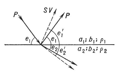
Fig. 2. Reflection and refraction of longitudinal waves (P) at the interface.
section in the Earth surface superfluidity occurs. When an inhomogeneous wave propagates SH A horizontal layer appears love wave. In the event of a wave incident on the boundary plane R Reflected waves can form in the layer R and SV. In this case, if a 2 > at 2 > a 1 > at 1, where a 1 and at 1 - velocities in a layer, a a 2 and at 2 - in an unsuitable environment, then as reflected R, both reflected and reflected SV for small e 1 they have the property of total internal reflection. As a result, Rayleigh waves form in the layer. They, like the Love waves, have a dispersion of velocities. Rayleigh waves arise in a half-space without stratification. Then they do not disperse and their speed from»0.9 at.
Waves R and S spread from the source by the volume of the Earth. They are called volumetric. Their amplitude for a homogeneous and isotropic medium decreases inversely proportional to the distance. Surface waves, propagating along the surface, have an amplitude that decreases inversely proportional to the square root of the distance. For this reason, oscillations from remote earthquakes in amplitude are dominated by surface waves.
Due to changes in the properties of the Earth with depth, the propagation velocities of volumetric SSs also change. This leads to their refraction in the bowels of the Earth.
Observations on the surface of the Earth over the propagation of solar radiation. allow to explore the structure of the Earth. Dependence of wave propagation velocity R and S from depth ( fig. 3 ) made it possible to reveal a number of shells of the "hard" Earth. Details of the structure of the Earth, see in Art. Earth.
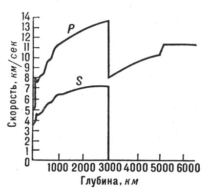
Fig. 3. Dependence of the velocity of longitudinal (P) and transverse (S) waves from the depth of the Earth.
BASIC CONCEPTS OF EARTHQUAKE SCIENCE
Earthquakes, underground impacts and fluctuations of the Earth's surface, caused by natural causes (mainly tectonic processes). In some parts of the Earth, the earths occur frequently and sometimes reach great strength, disrupting the integrity of the ground, destroying buildings and causing human casualties. The number of Z., annually recorded on the globe, is estimated at hundreds of thousands. However, the overwhelming number of them refers to the weak, and only a small fraction reaches the degree of the catastrophe. Until the 20th century. known, for example, such catastrophic Z., as Lisabonskoe in 1755, Vernenskoye in 1887, destroyed the city of Verny (now Alma-Ata), Z. in Greece in 1870-73, etc. Strongest Z. 20 century. are shown in Table. 3. According to the intensity, ie, by manifestation on the Earth's surface, Z., according to the international seismic scale MSK-64, divided by 12 gradations - points (see Table 1).
The area of the formation of the underground impact - the focus of the sun - is a certain volume in the Earth's thickness within which a process of release of energy accumulating for a long time occurs. In the geological sense, the focus is a gap or a group of discontinuities, over which an almost instantaneous movement of masses occurs. In the center of the hearth, there is a conditionally designated point called the hypocentre. The projection of the hypocentre on the surface of the Earth is called the epicenter. Around it is the area of greatest destruction - the isoseismic region. Lines connecting points with the same intensity of oscillations (in points) are called isoseists.
Dependence between the number of tremors N and their intensity in the epicenter I 0 is approximated by the formula: lg N =a + b I 0, where a and b are certain constants. From the hearth of Z. in all directions elastic seismic waves, among which there are longitudinal R and transversal S. Surface seismic waves of Rayleigh and Love are scattered on the surface of the Earth in all directions from the epicenter. Foci of S. occur at different depths ( h). Most of them lie in the earth's crust (at a depth of about 20-30 km). In some areas there are a large number of tremors emanating from the depths of hundreds km (the upper mantle of the Earth).
Z. - a powerful manifestation of the internal forces of the Earth. For each Z., a large amount of kinetic energy is released in the source E.So, in Ashgabat in 1948 E ~10 15 j, in San Francisco in 1906 E~10 16 j, in Alaska in 1964 E ~ 10 18 j. On the whole of the Earth, elastic energy (in the form of Z.) of the order of 0.5 · 10 19 j, which, however, is less than 0.5% of the total energy of the endogenous (internal) processes of the Earth.
The intensity 3, measured in points, characterizes the degree of concussion on the surface of the Earth, which depends on the depth of occurrence of the focus Z. The measure of the total energy of the waves is the magnitude Z. (M) is some arbitrary number proportional to the logarithm of the maximum displacement amplitude of soil particles, from observations at seismic stations and is expressed in relative units. The strongest Z has a magnitude no more than 9.
Table. 1. - Seismic scale (schematized)
| Score | The name of the earthquake | a brief description of |
| Imperceptible | It is noted only by seismic devices | |
| Very weak | Feels individual people in a state of complete rest | |
| Weak | Feels only a small part of the population | |
| Moderate | Recognized by the slight rattling and vibration of objects, dishes and window panes, creaking of doors and walls | |
| Quite strong | General shaking of buildings, furniture swing. Cracks in window panes and plaster. The awakening of the sleeping | |
| Strong | It is felt by all. Pictures fall from the walls. Splint pieces of plaster, light damage to buildings. | |
| Very strong | Cracks in the walls of stone houses. Antiseismic, as well as wooden buildings remain unscathed. | |
| Destructive | Cracks on steep slopes and on moist soil. Monuments are moved or overturned. The houses are badly damaged. | |
| The devastating | Strong damage and destruction of stone houses. | |
| Destructive | Large cracks in the soil. Landslides and landslides. Destruction of stone buildings. The curvature of the railway. rails. | |
| Catastrophe | Wide cracks in the earth. Numerous landslides and landslides. Stone houses are completely destroyed | |
| Strong disaster | Changes in soil reach enormous proportions. Numerous cracks, landslides, landslides. The emergence of waterfalls, podprud on the lakes, the deviation of the flow of rivers. No construction can withstand |
Table. 2. - Approximate ratio of magnitude and degree depending on the depth of the source
Table. 3. Strongest earthquakes of the 20th century.
| Date according to the new style (according to GMT) | Location of the epicenter (country, region, mountain system) | Mag-nituda | Strength, scores | Note |
| EUROPE | ||||
| 1908, December 28 | Sicily Island (Italy) | 7,5 | - | Messina and a number of other settlements in southern Italy were destroyed. Tsunami waves reached 14 m in height; killed 100-160 thousand people. |
| 1927, September 11 | Southern coast of Crimea, to the south of Yalta (USSR) | 6,5 | Up to 8 | Many buildings are damaged (from Sevastopol to Feodosia) |
| 1953, 12 August | Ionian Islands (Greece) | 7,5 | - | The settlements of the island of Kefallinia were destroyed; part of the island sank to sea level |
| 1963, July 26 | City of Skopje (Skopje, Yugoslavia) | 9 - 10 | Almost 80% of the city buildings are destroyed or damaged; killed more than 2 thousand people. | |
| 1969, 8 February | Near the southwestern coast of Portugal | - | Suffered the city of Lisbon, Casablanca and others. The surface of the earth was covered with cracks | |
| 1969, 27 October | South-western part of Yugoslavia | 6,4 | Catastrophic. The city of Banja Luka has been turned into a ruin | |
| ASIA | ||||
| 1902, December 16 | Ferghana Valley, Andijan (USSR) | - | Killed more than 4,5 thousand people. | |
| 1905, April 4 | Himalayas | - | ||
| 1905, July 23 | The Bolnai Range (Mongolia) | 8,2 | - | In the area of the Sangiin-Dalai-Nurkhrebta Lake Khan-Khuhei, a crack was formed 400 km long |
| 1907, October 21 | The southern slope of the Hissar Range (USSR) | - | Karatag and about 150 other settlements were destroyed; killed 1,5 thousand people. | |
| 1911, January 3 | The valley of the river. Kebin, the southern slope of the Zailiysky Alatau Ridge (USSR) | The city of Verny (now Alma-Ata) is destroyed; collapses, dams on mountain rivers | ||
| 1911, June 15 | The Ryukyu Islands (Japan) | 8,2 | - | Huge landslides and landslides; killed 100 thousand people. |
| 1923, September 1 | Honshu Island (Japan) | 8,2 | - | Catastrophic. Devastated Tokyo, Yokohama; killed about 150 thousand people. In the Sagami Bay tsunami waves reached 10 m altitude |
| 1927, March 7 | Honshu Island (Japan) | 7,8 | - | Catastrophic. The city of Mineyama was turned into ruins; killed about 1 thousand people. |
| 1938, 1 February | The Sea Banda (Indonesia) | 8,2 | - | |
| 1939, December 26 | Mountains Inner Taurus (Turkey) | 8,0 | - | Catastrophic; killed about 30-40 thousand people. On the Black Sea coast, water retreated 50 meters, and then flooded it 20 meters further than usual |
| 1941, April 20 | The valley of the river. Surkhob, the village of Garm (USSR) | 6,5 | 8 - 9 | Destroyed more than 60 settlements |
| 1946, November 2 | The northern part of the Chatkal range (USSR) | 7,5 | Hundreds of buildings in Tashkent and other cities are damaged; deformation of the earth's crust | |
| 1948, 5 October | Ashkhabad (USSR) | Catastrophic. Within 20 seconds, a significant part of the city was destroyed | ||
| 1949, July 10 | Gissaro-Alai mountain system, Hayit (USSR) | 7,5 | St. 9 | More than 150 settlements were affected |
| 1952, November 4 | Kuril Islands to the south-west. from the Shipunsky Peninsula (USSR) | 8,2 | - | Catastrophic. Tsunamis up to 18 m high caused extensive damage to the shores of Kamchatka and the northern part of the Kurile Islands |
| 1957, June 27 | Transbaikalia, the Muisky Range (USSR) | 7,5 | 9 - 10 | Destructions in Chita, Bodaibo and other settlements |
| 1958, November 6 | Kuril Islands to the south-west. from Iturup Island (USSR) | 8,7 | Tsunami | |
| 1960, April 24 | Lar (Iran) | - | The city is badly ruined; killed 3 thousand people. | |
| 1962, September 1 | Middle Iranian Mountains (Iran) | 7,8 | - | Destructive. Complete destruction of the village of Rudak; killed 12 thousand people. |
| 1966, April 25 | Tashkent | 5,3 | Destructions in the central part of the city. The shocks were repeated in May-July 1966 | |
| 1970, March 28 | Western Turkey | - | Catastrophic. A number of settlements have been turned into ruins; killed more than 1 thousand people. | |
| 1970, May 14 | Dagestan | 6,5 | Great damage was inflicted on the settlements of Buinakskiy, Gumbetovskiy, Kazbekovsky, Kizil'yurt and other districts | |
| 1971, May 22 | Eastern Turkey | 6,8 | - | The cities of Bingöl and Genç were destroyed; killed more than 1 thousand people. |
| 1971, October 5 | Japanese Sea | 7,3 | - | One of the most powerful earthquakes in the history of Sakhalin Island |
| Australia and Oceania | ||||
| 1906, October 14 | Basin of Bougainville | 8,1 | - | |
| 1931, 2 February | New Zealand (North Island) | 7,8 | Catastrophic. Destructions and fires | |
| 1966, 31 December | The islands of Santa Cruz (British) | - | ||
| AFRICA | ||||
| 1960, February 29 | City of Agadir (Morocco) | The city of Agadir was completely destroyed; killed 12-15 thousand people. | ||
| NORTH AMERICA | ||||
| 1906, April 18 | Coastal ranges Cordillera (California, USA) | 8,2 | - | Destroyed much of San Francisco |
| 1964, March 28 | Prince William Bay (USA) | 8,6 | 10-11 | Tsunamis up to 9 m high reached the coast of Canada, the USA, Hawaii and Japan |
| 1971, 9 February | California (USA) | 6,7 | - | The strongest earthquake in Los Angeles in the past 40 years |
| SOUTH AMERICA | ||||
| 1906, 17 August | Coastal Cordillera (Chile) | 8,4 | - | In Valparaiso, the coastline was raised; tsunami crossed the ocean, reached Japan and the Hawaiian Islands |
| 1960, May 22 | District of Concepción (Chile) | 8,8 | - | Destructive. Tsunamis reached the USA, the Hawaiian and Kurile Islands, Australia and Japan; killed about 10 thousand people. |
| 1961, 19 August | Brazil | - | ||
| 1970, December 10 | Coast of Peru | 7,3 | - | About 5 thousand houses were destroyed. Over 20 thousand people. left homeless |
Between the number Z. ( N) and their magnitude ( M) there is a relationship, which is approximated by the formula: lg N= a-bM, Where a and bare constants. The energy of Z. ( E) is related to the magnitude by a relation of the form: lg E= a 1 + b 1 M. For the coefficients a 1 and b 1 different values are given, but the most appropriate ones are a 1close to 4, and b 1- to 1.6. Value K= lg E is sometimes called the energy class 3. For Z, for which M = 5, the energy is released from the source ~ 10 12 j, TO= 12; at M = 8, O E~ 10 17 j, TO= 17. Magnitude ( M), the intensity ( I o) and depth of hearth ( h) are related. For an approximate determination of one of these quantities by the other two, Table 1 can be used. 2.
In recent decades, widely developed methods of statistical analysis have been developed extensively. With their help, maps of seismic activity and maps of shaking (the average frequency of one or another energy class at a given point) are compiled, as well as repetition patterns (the dependence of the frequency Z on their magnitude ). Z. distributed on the earth's surface is very uneven (see. card * ). They are associated with areas of the earth's crust, in which the newest differentiated tectonic movements are manifested. There are two main seismic belts of the world-the Mediterranean, extending through the south of Eurasia from the shores of Portugal to the west to the Malay Archipelago in the west, and the Pacific, which encompasses the shores of the Pacific Ocean. These belts include young folded mountain structures, ie, epigeosynclinal orogens (the Alps, the Apennines, the Carpathians, the Caucasus, the Himalayas, the Cordilleras, the Andes, etc.), as well as the mobile zones of the continental underwater margins, which many researchers interpret as modern geosynclinal regions or fold systems in the initial stage of development (the western periphery of the Pacific Ocean with island arcs of the Aleutian, Kuril, Japanese, Malay, New Zealand, etc., Caribbean, Mediterranean and other seas). Beyond the boundaries of these belts within the continents, the epicenters of the earth are confined to the regions of the newest tectonic activation (epiplatform troughs of the Tien Shan type), as well as to rift zones accompanied by the formation of fault systems (rifts of East Africa, the Red Sea, The Baikal rift system and etc.). Within the oceans, significant seismic activity mid-ocean ridges. On the platforms and on most of the bottom of the oceans of the Z. Occur rarely and do not reach much power.
A thorough analysis of the mechanism of the formation of an underground impact shows that the earth represents the reaction of the material of the Earth's crust or mantle of the Earth to tectonic stresses that constantly accumulate in the bowels of the Earth. Compressive stresses prevail, although tension stresses are observed in places.
The analysis of seismic, geological and geophysical data allows us to outline in advance those areas where we should expect Z in the future, and to estimate their maximum intensity. This is the essence seismic zoning. In the USSR, a seismic zoning map is an official document that must be taken into account by design organizations in seismic regions. Strict compliance with the norms of earthquake-proof construction can significantly reduce the destructive impact of Z. on buildings and other engineering structures. The main way to solve this problem is to carefully register the "harbingers" of Z. - weak preliminary shocks (foreshocks), deformation of the earth's surface, changes in the parameters of geophysical fields, and other changes in the state and properties of matter in the zone of the future hearth Z.
Z. began to be described from ancient times. In the 19th century. catalogs were written for the whole world (J. Miles, R. Mallet), for the Russian Empire (IV Mushketov, A. P. Orlov), and others, monographs on the strongest and well-studied Z. ( especially in Italy). In the early 20 century. The main attention was paid to the geological side of the Z. (the works of KI Bogdanovich, VN Weber, DI Mushketov and many others in Russia, F. Montessue de Ballora, A. Sieberg and many others abroad), the development of seismometric equipment and the creation of seismic stations (BB Golitsyn, PM Nikiforov, AV Vichert, DA Kharin, DP Kirnos, and others). Z. became the object of study of a special branch of knowledge - seismology.

Send your good work in the knowledge base is simple. Use the form below
Students, graduate students, young scientists who use the knowledge base in their studies and work will be very grateful to you.
Hosted on http://www.allbest.ru/
Introduction
In the bowels of our planet, there are continuous internal processes that change the face of the Earth. Most often these changes are slow, gradual. Accurate measurements show that some parts of the earth's surface rise, others drop. Even the distances between continents do not remain constant. Sometimes internal processes are stormy, and the terrible element of earthquakes turns into the ruins of the city, devastates entire areas.
Under the threat of earthquakes are vast areas, many densely populated areas and even entire countries, such as Japan. The greatest danger of earthquakes lies in their surprise and inevitability. However, the scientific achievements of recent years offer real opportunities not only to predict earthquakes, but also to influence their progress.
The concept of an earthquake
The word "earthquake" is Russian, and its meaning is clear: an earthquake is a shaking of the earth. More precisely, an earthquake is a vibration of the earth's surface as waves pass from an underground source of energy.
In Greek, the earthquake is seismos, therefore, seismic phenomena are those related to earthquakes, namely seismic waves, seismic instruments (seismographs), seismic records (seismograms), seismic stations, etc.
Earthquakes are an important part of our environment, and no region of the globe can be considered completely rid of them. Seismologists work in all developed countries, as well as in many developing countries. They are interested in why and how earthquakes occur. Studying the waves passing through the Earth during earthquakes, scientists recreate the essential details of its internal structure. The methods developed for this study proved to be useful also in the search for oil and other minerals. In countries where earthquakes occur frequently, important social and economic problems arise, architects and engineers must solve special tasks. Thus, seismology serves both the practical activities of man and the knowledge of the fundamental laws of nature.
Seismology is part of a broader science - geophysics, which arose as the intersection and connecting link of the two older sciences - geology and physics. Geology in the broadest sense of the word is engaged in a comprehensive study of the Earth, but at the present time, as a rule, it is generally considered a descriptive study of the origin and properties of rocks and the fossils contained in them, as well as transformations of the earth's surface under the influence of high temperatures, pressure, electricity and other forces. The scope of geophysics thus includes sections of geology related to physical measurements and calculations, and sections of physics that examine the Earth and its atmosphere.
Early explanations of the causes of earthquakes
In search of the causes of earthquakes, Aristotle turned to the depths of the Earth. He believed that atmospheric vortices are embedded in the ground, in which there are many voids and through gaps. Vortices, he thought, are intensified by fire and seek their way out, thus causing earthquakes, and sometimes volcanic eruptions. These ideas existed for many centuries, even though he did not give any arguments in favor of his hypotheses, but simply gave vent to his wild imagination. Aristotle is also "responsible" for the current and still understanding of the special "seismic weather". He said that when the air is drawn into the earth before the earthquake, the air left above the ground becomes calmer and more discharged, making breathing more difficult. Fourteen centuries later, Pliny wrote: "The shaking of the earth happens only when the sea is calm and the sky is so motionless that birds can not soar because there is no breath supporting them." Since such conditions occur in hot, humid weather, this weather was called "earthquake-prone weather", believing that it signals the approach of earthquakes.
In the mythology of different nations, there is an interesting similarity in the notions of the causes of earthquakes. It's like the movement of some real or mythical animal, a giant hidden somewhere in the depths of the Earth. The ancient Hindus have an elephant, the Sumatran dyaks have a huge ox. The ancient Japanese blamed the earthquakes for the catfish, which shook the earth. If he had not been under the supervision of the good god Daimedzin,
then the earth would shake all the time. However, the good spirit from time to time lost its vigilance, and the conscience of the evil catfish was burdened by the next earthquake.
Earthquakes were often viewed as punishments sent down by angry gods. In the Greek mythology of the earthquake, an angry Poseidon, lord of the seas, provokes. Neptune, his counterpart in Roman myths, could not only instill fear into people, causing an earthquake, but also send floods to the earth, and on the shore - huge waves. In Europe, the XVIII century. The clergy tried to instill in people a moralistic view of earthquakes. Here's what you can read in a London newspaper for 1752: "Earthquakes usually happen in big cities. The punishing whip is directed to where there are inhabitants, i.e. a goal for caution, and not on bare cliffs and uninhabited shores. " The famous Lisbon earthquake of 1755. happened on All Saints' Day, at a time when people were in church. A huge number of victims was caused by a series of some tremors and a giant tsunami that struck the embankment. The situation was aggravated by fires that raged throughout the city. Those who believed in God's punishment for their sins saw retribution in this.
Modern explanations of the causes of earthquakes
The science of earthquakes, seismology, although young, has made serious progress in understanding the object of its research. The names of A.P. Orlova, I.V. Mushketov, K.I. Bogdanovich, V.N. Weber, B.B. Golitsyn, G. A. Gamburtseva, S.V. Medvedeva, Yu.V. Riznichenko - bright reference points on the growth curve of domestic and world seismology.
By the efforts of several generations of researchers, experts now have a good idea of what happens during an earthquake and how it manifests on the surface of the Earth. But after all, surface phenomena are the result of what happens in the bowels. And the main focus of specialists is now focused on understanding the deep processes in the bowels of the Earth, the processes leading to the earthquake, its accompanying and following.
The theory of earthquakes as a geophysical process is only being developed. Although this kind of research is now widely used physical and mathematical modeling, the knowledge of various natural phenomena associated with earthquakes is largely based on observations on the earth's surface.
Scientific geology (its formation dates back to the 18th century) has drawn the right conclusions about the fact that the youngest sections of the earth's crust are shaken. In the second half of the nineteenth century. a general theory has already been chosen, according to which the earth's crust was divided into ancient stable shields and young, mobile mountain structures. It turned out that the young mountain systems - the Alps, the Pyrenees, the Carpathians, the Himalayas, the Andes - are subject to a strong earthquake, while the ancient shields (to which the Czech Massif belongs) are areas where strong earthquakes are absent.
Among the most common seismological terms associated with the concept of "earthquake", include the following: the hearth, hypocentre, epicenter, magnitude, score.
Under the focus of the tectonic earthquake is understood the closed volume of terrestrial matter, in which a short enough time, up to 1-3 minutes, occurred destruction. As a rule, in the region of the focus there is a shift (shift) of one part of the volume relative to the other. The place where the shift begins is called the hypocentre. It is from this point that the generation of seismic waves begins, which can lead to destruction outside the hearth. The projection of the hypocentre vertically on the earth's surface was called the epicenter.
The concept of a score characterizes the intensity of the shock at the observation point. In our country since 1964 the 12-point scale MSK-64 is used. It should be noted that not seismologists in points often characterize the very strength of an earthquake in the hearth. This is not true, but it occurs regularly in newspaper reports. As a rule, this applies to the Richter scale, which uses the dimensionless magnitude M of the earthquake, which is proportional to the logarithm of the energy released in the source. Confusion arose in connection with two circumstances: 1) the magnitude of the earthquakes known so far does not exceed 9 units (in catalogs there is only M (max.) Is 8.9), that is, the magnitude is numerically close to the values of the concussion points; 2) we are used to the fact that any parameter has a dimension (meters, kilograms, degrees), and after all the logarithms of any parameters are always dimensionless. Therefore, if in the press there are messages like "the earthquake had 7 points on the Richter scale," in reality this means that the earthquake magnitude is M = 7. And it can be felt in different points by force 10 points, 8 points, 5 points - this depends on the distance to the hearth. Thus, if the glossiness depends on the distance to the source, then the magnitude does not depend. The MSK-64 scale is designed for buildings and structures that do not have earthquake-resistant reinforcement structures. I will give here the description of the first four points of this scale without changes, and starting with the fifth, when damage to buildings is possible, I will describe the main distinguishing features of earthquakes and their likely impact on the buildings of modern buildings in Kamchatka. When describing each point in parentheses, the frequency of occurrence of earthquakes of a given force for Petropavlovsk-Kamchatsky is indicated.
1 point. An impassable earthquake. The intensity of the oscillations lies below the sensitivity limit, ground tremors are detected and recorded only by seismographs.
2 points. Weak earthquake. The vibrations are felt only by individual people inside the room, especially on the upper floors.
3 points. Weak earthquake. It is felt not by many people inside the premises, under the open sky - only under favorable conditions. The oscillations are similar to the concussions created by a passing light truck. Attentive observers notice a slight swaying of hanging objects, somewhat stronger on the upper floors.
4 points. Noticeable concussion. The earthquake is felt inside the building by many people, under the open sky - by a few. In some places they wake up, but no one is frightened. The oscillations are similar to the concussion created by a passing heavy truck. Rattling around the doors, dishes. The creaking of walls, floors. Trembling of furniture. Hanging objects swing slightly. The liquid in the open vessels slightly fluctuates. In the cars standing in place, the push is noticeable.
5 points. (15-25 times in 100 years). Almost all sleepers wake up, the water in the vessels vibrates and partially splashes, light objects can topple, dishes may break. Buildings are not damaged.
6 points. (10-15 times in 100 years). Many people are frightened, hesitation stops walking. The buildings are staggering, pendant lamps are strongly rocking. Drops and beats dishes, objects fall off the shelves. Furniture can move. Shedding whitewash, thin cracks in the plaster.
7 points (4-6 times in 100 years). Strong fright, hesitation prevents you from standing on your feet. Moving and falling furniture. In any building - cracks in the partitions. Cracks in the plaster, thin cracks in the walls, cracks in the seams between the blocks and in the septums, the fall of the seams, often thin cracks in the blocks.
8 points. (1-3 times in 100 years). Knocking down. Cracks in the ground on the slopes. In any buildings - damage, sometimes partial destruction of partitions. Cracks in the bearing walls, plaster slips, displacement of blocks, cracks in blocks.
9 points. (approximately once in 300 years). Cracks everywhere in the ground. On the slopes - landslides of soil. In any buildings - collapse of partitions. Destruction of some bearing walls, damage and displacement of some panels. Chopped houses from logs and timber, as a rule, suffer 9-point shocks without destruction.
Causes of earthquakes
The causes of earthquakes will immediately become clear, as soon as we imagine the dynamic nature of the Earth and those slow movements that occur in its crust - the lithosphere. The thickness of the cortex is very variable. Under the continents, it is 30-35 km, and large mountains, which are much higher than the average level of the earth's surface, are almost always accompanied by deep "roots". Thus, in Tibet, the thickness of the crust was more than 70 km. The base of the crust under the oceans is about 10 km below sea level. Its small thickness is well illustrated by this example: if the Earth is reduced to the size of the egg, then the hard bark will be thick with shell. This solid layer, however, is not integral: it is broken into several large pieces called plates.
Under the lithosphere, forces force the plates to move at a speed, usually a few centimeters per year. The reason for these deep forces is not completely clear. They can be caused, for example, by slow currents of hot plastic substance in the bowels. Currents arise as a result of thermal convection in combination with the dynamic effects of the Earth's rotation. In some areas, the new substance rises upward from the earth's interior, pushing the plates aside (this occurs, for example, in the Mid-Atlantic ridge); in other places slip one along the other (as along the San Andreas fault in California); there are areas called subduction zones (subduction), where one plate is pushed under the other under the other (for example, in the ocean near the western shores of South and Central America, off the coast of Alaska and Japan). The inconsistency in the movement of plates in any direction causes the rock stratification to crack, thus creating earthquakes.
It is not surprising that most earthquakes (almost 95%) occur along the edges of the plates. Earthquakes, caused by the movement of plates, are called tectonic. Although they usually occur at the plate boundaries, a small fraction of them occur inside the plates. Some other earthquakes like, for example, the Hawaiian Islands, are of volcanic origin and very rarely they are caused by human activities (filling reservoirs, pumping water into boreholes, mining work, large explosions).
The earthquake zone surrounding the Pacific Ocean is called the Pacific Ocean belt: about 90% of all earthquakes in the world occur here. Another region of high seismicity, comprising 5-6% of all earthquakes, is the Alpine belt stretching from the Mediterranean to the east through Turkey, Iran and Northern India. The remaining 4-5% of earthquakes occur along the mid-ocean ridges or inside the plates.
Catastrophic earthquakes
Of the huge number of earthquakes that occur annually, only one has a magnitude equal to 8 or more 8. Any earthquake with a magnitude above 7 points can become a major catastrophe. However, it may remain unnoticed if it occurs in a deserted area. Thus, the great natural disaster - the Gobi-Altai earthquake (1957, magnitude 8.5, intensity 11-12 points) - remains almost unexplored, although due to the enormous strength, small depth of the focus and the absence of vegetation, this earthquake left on the surface the most complete and diverse picture (there were 2 lakes, instantly formed a huge overthrust in the form of a stone wave up to 10 m high, the maximum displacement of the discharge reached 300 m, etc.). The territory of 50-100 km wide and 500 km long (like Denmark or Holland) was completely destroyed. If this earthquake occurred in a densely populated area, the number of victims could be measured in millions.
The consequences of one of the strongest earthquakes (the magnitude could be 9), which occurred in the oldest region of Europe - Lisbon - in 1755 and seized the territory of more than 2.5 million square meters. km, were so grandiose: 50,000 people died (230,000 of them were urban dwellers), the rock grew in the harbor, the coastal bottom became land, the outline of the coast of Portugal changed. This shocked the Europeans so much that Voltaire responded to him with a "Poem about the death of Lisbon" (1756, Russian translation, 1763). Apparently, the impression of this catastrophe was so strong that Voltaire in the poem challenged the doctrine of pre-established world harmony. Strong earthquakes, no matter how rare they are, never leave their contemporaries indifferent. So, in the tragedy of William Shakespeare's "Romeo and Juliet" (1595), the nurse recalls the earthquake of 1580, which, apparently, the author himself experienced.
The mechanism of earthquakes and their classification
Mountain-forming, volcanic and seismic processes geographically gravitate towards each other. However, in time they occur, as a rule, not simultaneously and always with different duration. In addition, there are areas with a pronounced seismic activity only. For example, many Central Asia are highly seismic, but do not have volcanoes. In Kamchatka and Chile, volcanoes and earthquakes occur on the same territory, but rarely at the same time.
Many of the seismologists, referring to the mechanism of earthquakes, adhere to the theory of elastic release or elastic recoil. They connect the occurrence of earthquakes with the sudden release of energy of elastic deformation. As a result of prolonged movements in the fault area and the accumulation of stresses in this connection, reaching the ultimate value for rock strength, a break or shear of these rocks occurs with a sudden rapid displacement-elastic recoil, resulting in seismic waves. Thus, very slow and prolonged tectonic movements in an earthquake are transformed into seismic movements that are characterized by a high rate, which occurs as a result of rapid "discharge", accumulated elastic energy. This discharge occurs in just 10-15 seconds (rarely in 40-60 seconds).
When the earthquake is born, the rock is destroyed in a limited area located at a certain depth from the surface of the Earth. In connection with the emerging weakening, a dislocation develops to the focus or hypocentral part of the earthquake region. Destruction will occur where the breed is least durable, and this may be in faults between blocks. Due to some deep processes, individual sections of the crust are raised or lowered. With a slow displacement in the earth's crust, plastic deformations occur. With more rapid movements and with a higher gradient, the stresses arising in the cortex do not have time to resolve before they can dissolve, they reach values at which, under the given conditions, there is a discontinuity - either over the finished, partly already healed rupture, or with the formation of a new one. As the depth increases, the compres- sive compressive stresses increase, and therefore large friction forces arise that prevent rapid destruction. Perhaps, for this reason, deep-focus earthquakes are characterized by great energy and duration.
Currently, the most common are two models of the spread of forces that cause a gap in the source. The first is based on the assumption of the action in the focus of a pair of forces causing tangential forces along the line of discontinuity and torque; According to the second model, there are two mutually perpendicular pairs of forces in the focus zone.
In addition to earthquakes caused by tectonic movements in the earth's crust and in the upper layers of the mantle, there are two other types of earthquakes that occur as a result of volcanic eruptions and karst phenomena, which are very local, rare, and of little force. Earthquakes can be caused by artificial means, for example, in an underground explosion. Surface fluctuations may be caused by land and the operation of industrial equipment, traffic, etc. When using sensitive equipment, you can make sure that the surface of the earth constantly fluctuates; these oscillations are very small and for this reason are called microseismic. The presence of microseisms makes it possible to extract very useful information, both for seismologists and for civil engineers.
Thus, in a broad sense, the term earthquake can be understood as any earthquake shaking. In a narrower sense, an earthquake is a short-term shock of the Earth's surface caused by seismic waves that occurred when local continuity is disturbed, with sudden release of elastic energy in the depths of the crust or upper mantle (up to about 700 km).
At some point in the earthquake, an obstacle arises between the mutual displacement of the blocks along the formed seams - the bonds of the ruptured seam are partially restored, which can serve as frictional forces (their appearance is possible in compressed areas), engagement on surfaces. The non-liberated part of the energy causes stresses in the new connections, which after a while overcome their resistance, a new gap and a new impetus, but less force than at the time of the main earthquake. These repeated jerks - aftershocks - after a strong earthquake are usually up to several hundred, and they occur for several months, gradually weakening. The process of weakening the tremors in time is not uniform. Individual aftershocks in strength can approximate the strength of the main earthquake. Sometimes earthquakes are preceded by weak tremors - foreshocks. In cases where earthquakes or volcanoes occur under the ocean floor, they excite sea waves, which, reaching the shores of the land and meeting their resistance, rise to a height of several tens of meters. Such waves - tsunami (in Japanese, "tsu" - port, "us" - wave) - from time to time bring coastal areas of great trouble.
There are two groups of seismic waves - volumetric and surface ones. The rocks forming the Earth are elastic and, therefore, can deform and undergo fluctuations when the pressure (loads) is sharply applied. Inside the volume of rocks propagate volume waves. They are divided into two types: longitudinal and transverse. Longitudinal waves in the body of the Earth, as well as the usual sound in the air, alternately compress and stretch the rock matter in the direction of its movement. Waves of another type vibrate the medium through which they pass, across the path of their movement. It is they who, when they come to the surface, swing from side to side and up and down everything on the ground, leading to the greatest destruction. Precisely because the surface of a solid Earth is a boundary with a much less dense medium, airy (it is called a free surface), on the earth's surface, volumetric seismic waves can be more freely "roam", which usually happens. This is facilitated by the properties of near-surface soils.
Very important properties of different groups and types of seismic waves, especially the speed of their passage through the rocks. Usually it is measured several kilometers per second and consequently, at different distances from the focus (hypocentre and epicenter), the arrival of waves is felt and recorded non-simultaneously. On this property, the determination of the coordinates of the epicenter based on the records of arrival of waves on remote seismic stations is based. No less important is the difference in the speeds of individual groups and types of waves. So surface waves propagate more slowly than volumetric ones and, therefore, come to observation points later. In the bulk group, the transverse waves propagate an average of 1.75 times slower than the longitudinal ones. Hence it is clear why people in the epicentral region of a strong earthquake often fall into the power of waves: they are pushed, shakes, shakes in different directions with different accelerations.
Eyewitnesses often "hear" earthquakes in the literal sense of the word. Longitudinal waves are similar to sound waves. At a certain frequency of oscillations (in the range of audible waves, that is, more than 15 hertz), they come to the surface and become sound waves. If we recall that the longitudinal waves propagate faster and the transverse waves often carry the main disruptions, it is easy to understand why hum can be heard before the earthquake. Here a lot depends on the radiation spectra.
Earthquakes are classified according to the depth of their focus. They are divided into the following three types:
· Normal - with depth of focus 0-70 km;
· Intermediate - 70-300 km;
· Deep-focus - more than 300 km.
Conclusion
However, the problem of "what to do with the forecast" remains. Some seismologists would have considered their duty fulfilled by submitting their warning by telegraph to the Prime Minister, while others are trying to connect sociologists to the question of what the most likely public reaction to the warning will be. A simple citizen is unlikely to be pleased with the message that the city council suggests that he look at a picture in the open air in the city park, if he knows that his house will most likely be destroyed in one or two hours.
There is no doubt that the social and economic problems that will arise as a result of the warning will be very serious, but what really happens to a greater extent depends on the content of the warning. At present, it seems likely that seismologists will first make advance warnings, perhaps for several years ahead, and then gradually specify the time, location and possible magnitude of the expected earthquake as it approaches. After all, it is worthwhile to make a warning, and insurance premiums, as well as real estate prices will change dramatically, population migration may begin, new construction projects will be frozen, unemployment among workers engaged in repairing the coloring of buildings will begin. On the other hand, there may be an increased demand for camp equipment, fire fighting equipment, essential goods, which will be followed by their shortage and rising prices.
It is necessary to clearly distinguish predictions, the source of which may or may not be trustworthy, and warnings that should be of the nature of official indications of the need to implement certain practical measures.
Whatever the prospects for forecasting or controlling, it is obvious that the number of earthquake victims and economic losses can be significantly reduced if specialists direct their ingenuity and labor primarily to developing more reliable building standards and creating better building structures. earthquake warning fire camp
Every earthquake is a lesson, and an exam. And not only for seismologists, specializing and, perhaps, the most capable students in the class of earthquakes in the School of Nature, but also for designers, land surveyors and economists. Moreover, for all residents affected by underground storms.
List of used literature
Vikulin AV, Semenets NV, Shirokov VA "The earthquake will be tomorrow" P-Kamchatsky, 1989.
Zdenek Kukal "Natural Disasters" Publishing house "Knowledge" Moscow, 1985.
Nikonov AA "Earthquakes" Publishing house "Knowledge" Moscow, 1984.
Polyakov S.V. "Consequences of strong earthquakes" Publishing house "Stroyizdat" Moscow, 1978.
Abie J.A. "Earthquakes" Publishing house "Nedra", Moscow 1982г.
Hosted on Allbest.ru
Similar documents
The theory of earthquakes as a geophysical process, early and modern explanations of their causes. The mechanism of earthquakes, their classification, the basic concepts: focus, hypocentre, epicenter, magnitude, score. Prospects of prediction, difficulties and forecast problems.
summary, added 07/03/2011
Study of the concepts of the focus and epicenter of the earthquake. Classification of earthquakes for reasons of their occurrence. Study of the magnitudes scale. Descriptions of the largest catastrophic earthquakes of the twentieth century. The consequences of earthquakes for cities and people.
presentation, added on 05/22/2013
Study of the main causes and nature of earthquakes - rapid displacements, vibrations of the earth's surface as a result of tremors. Features of deep-focus earthquakes. Characteristics of methods and devices for the detection, registration of seismic waves.
summary, added on 04/06/2010
Modern problems of seismology. Geographical distribution of earthquakes, their causes, mechanism of occurrence, classification. General information about the methods of their prediction and antiseismic measures. Distribution of seismic belts on the globe.
term paper, added on July 18, 2014
Modern knowledge of earthquakes. Classification of earthquakes by the way of their formation. Types of seismic waves that occur during earthquakes. Propagation of elastic waves. The magnitude of surface waves. The role of water in the occurrence of earthquakes.
course work, added 02.07.2012
What happens in strong earthquakes. Types of seismic waves that occur during earthquakes. Slippage on faults; friction clay. Attempts to predict earthquakes. Features of the spatial distribution of foci of earthquakes.
course work, added 14.03.2012
Historical information and results of monitoring seismic events on the globe during the second half of the 20th century. Basic concepts and characteristics of earthquakes. Methods for assessing the strength (intensity) of earthquakes. Types of geological faults.
summary, added on 05/06/2011
Causes and classification, examples and forecast of earthquakes. Denudation, volcanic, tectonic earthquakes. Moretryaseniya, the formation of formidable sea waves - a tsunami. Creation in the seismically dangerous areas of observation points for precursors.
the abstract, added 13.09.2010
The definition of earthquakes as powerful dynamic impacts, having a tectonic nature. Ground behavior in earthquakes and causes of destruction. The main types of seismogenerating zones. Drawing up maps of seismic and volcanic activity.
essay, added on 09/03/2012
Analysis of the connection between natural pulsed electromagnetic radiation and global seismic activity from observations far from local disturbance sources. The study of perturbations in the ionosphere, arising a few days before strong earthquakes.
Publications on the topic
-
 How to build a network
Despite all the dislike of mankind for spiders, as well as the abundance of prejudices and terrible stories associated with them, the question is, like a spider ...
-
 Game Mouse. Mickey Mouse Games
How long ago did a famous cartoon appear, whose main role was played by the beloved Mickey Mouse? This hero was brought up by more than one generation of children, ...