
Vilyuchinsky ski resort, a volcano in the Kamchatka region. CAAs - Kamchatka Peninsula. Volcanoes Vilyuchinsky, Mutnovsky and Gorely

How to get to the volcanoes Mutnovsko-Gorelovskaya group
A good road leads to the volcanoes, ending at the Mutnovskaya Geothermal Power Station. The road starts one and a half kilometers to the final stop in the village of Termalny, where you can easily get to the shuttle bus from the bus station in Petropavlovsk or Yelizovo, and then go parallel to the power line up the valley. Past a couple of good camp sites with thermal pools about 30 km to the Vilyuchinsky waterfall at the foot of the volcano of the same name.
Then the road goes through the Vilyuchinsky pass to the base of the road workers. On the way down from the pass to the left, a branch goes to the Zhirovsky hot springs. The main road leads to a vast volcanic plateau. After about 11 km (25 km from the waterfall), turn right to the “brick” turn to the Asacha field. This primer passes right through the caldera of Gorely volcano, to its foot only 3 km.
After another 10 km, the road comes to the checkpoint before entering the geothermal power station. There is free parking. Further to Mutnovsky volcano and the surrounding area on foot. Now they are not allowed into the territory of the power plant, but there is a detour - along the packed path to the right below the slope. Tourist camps are located on flat grounds in the ravine of the Kotel stream, under the hotel of powermen "Puck". No shop.
If there is no possibility to drive by car from the city - it does not matter. In good weather, especially on weekends, there are quite a lot of cars going on Mutnovka, so they will surely give you a lift. You can try to fit into the crew of the travel agency, but the tour should not be taken, perhaps. The average tour lasts a couple of days, its price fluctuates around 5-6k, and it’s impossible to see all the sights.

Vilyuchinsky volcano, 2173 m
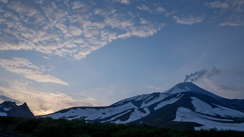
Gorely volcano, 1829 m
A large volcano with a well-guessed Shield base, which is generally unusual for Kamchatka (more typical of Hawaiian and Icelandic volcanoes). Gorely is a wide ruined ridge about three kilometers long, consisting of the walls of three main craters, and the numerous surrounding cones of side breaks. Geographically, the volcano is part of the South Kamchatka Natural Park, however, no permits or permits to visit it are required.
|
|


All ridges and craters are located in a vast volcanotectonic depression measuring 9 by 13 km. The landscape of the caldera hollow resembles the lunar one. The similarity adds the almost complete absence of vegetation and in general any kind of life to the horizon. Of course, besides tourists :) Volcanic activity is quite high, there are many fumaroles, and the lake in one of the craters almost boils. In 2010. Gorely tried to erupt, and lava rose into the central crater.
What to see. In technical terms, the ascent of interest is not, however, the volcano is very picturesque and, most importantly, not similar to other volcanoes nearest to the city. From the turn of the road in the caldera (about 1000m above sea level), along the largest ridge to the main crater there is a well-filled path. But you can also climb to all side craters and walk along all the ridges.
Around open views of the multi-colored lava flows, pyroclastic outcrops of bizarre forms and rocky cliffs. To the west from Gorely to the Tolmachevsky reservoir, tundra wastelands, slag fields and old destroyed lava flows stretch. For a walk you need to lay at least one full day. When choosing a place to spend the night, it should be borne in mind that at the end of the season water in the caldera is far from being everywhere.
There are several small caves in the lava flows in the northwest corner of the caldera. There are ruts to their entrance from the road, so finding a place is not a problem. The coordinates of the entrance to the largest of the caves are 52 ° 36.341 ", 158 ° 00.265". The passage to the lava flow is not at all deep, it is rather a wide grotto. But the place is picturesque, and the bottom is in a grotto of ice.
All modern craters are merged into a single funnel with a strongly broken glacier flowing down from the northern slope and multiple fumarole fields. Fumaroles and thermal outlets are also available on the outer slopes. From the north, the main buildings of the volcano are confined to the ridge with the Dirved and Rocky intrusive hills.
Mutnovka is part of the South Kamchatka Natural Park. You can stand with tents here, except for the territory of the power station, but tourists arriving here are asked to register for free at the park office in the city. In reality, no one registers; during high season, a voluntary registration center (cottage) is sometimes open on the way to the crater.
The surroundings of the volcano are characterized by changeable weather. When it is sunny, it’s almost paradise here, but in a matter of hours the clouds can fly and a very bad weather begins. Often, for three or four days, a cloud hangs 50m above the ground, from which, at a daytime temperature of + 7 ° C, it mercilessly pours with a slanting rain under gusts of heavy wind. If you come to Mutnovka for more than one or two days, you should be ready for this!
From the weather you can escape the hotel power, the so-called "Puck". This three-star miracle can not be overlooked, living in 2011 cost 2000 rubles, food - another 360 rubles. It is better to negotiate a possible settlement in the city, in the office of Geotherm. A conspicuous building with a tower and a satellite dish is located at a roundabout at the entrance to the Northeast neighborhood, next to the Siluet stop.
What to see. The surroundings of the Mutnovsky volcano are overflowing with tourist sites, visiting of which in itself is worthy of a separate trip.
1.
Hills Rocky (1413m) and Dvougorbai (1503m). From the power station up to the volcano is the old road geologists-drillers, passing right at the eastern foot of the picturesque hills. Above the road, black-capped marmots and evrazhki live on gentle grass slopes. Panoramic views of volcanoes and all of southern Kamchatka open from the top of the hills.
2. Hot Springs. To the territory of the power plant from the south there are 2 thermal sites adjoining. To the west (closer to the entrance to the station), in the valley of a small stream are Duck springs with boiling mud pot. Somewhat further, in a deep gulf are Dacha springs with fumaroles and a small geyser. There is a small man-made "bath" with thermal water.
 |
3. "Southern Polygon" and canyons of the tributaries of the Falshivaya River. From the hotel "Puck" through the Dacha springs, along a good path, you can climb a plateau under the slopes of the volcano. The trail connects with a primer that runs parallel to the river canyon along the foot of the volcano. On the way there are views of the picturesque valley and waterfalls. The road ends at the site with wells, where the ground is pierced by breakthroughs of underground pressureal thermal solutions. From the landfill you can go down the picturesque canyon to the river. Walk takes 4-5 hours.
4. Central crater of the Mutnovsky volcano. On the serpentine road past the hills of Rocky and Dvougorbai to the wide pass between Dvougorba and Mutnovka. From here get off the road and along the trail going to the south-west, bypassing the ridge Leaving to go to the canyon Opasny in the headwaters of the Mutnaya river. If the path is not immediately found, it is possible without it :)
Rise. The route of technical complexity is not, but a person without experience can tickle slightly. Objectively, in good weather, everything is safe.
Along the same road as when climbing into the crater, go all the way to the second geothermal site with old wells right under the volcano slope (about two hours from the power station). At the end of the road branches, it is better to keep the left track. From the site on a gentle left snowfield or scree slope, through a belt of simple ruined rocks, climb to the plateau in front of the crater, then through the plateau to a wide ridge, steeply ending on the other side into the crater (about one and a half hours from the foot)
By traversing the two gendarmes of the summit ridge along the compacted slags and scree under the transverse comb with fingers-remnants. Climb over the scallop along the large block sypuha in the lowest place, and then go along the wide ridge to the top (about 40 minutes more).
The tragedy that occurred in April 2017 on the slope of the Vilyuchinsky volcano on Kamchatka caught the attention of the public. The avalanche that took the life of a man and a child makes one think about the safety of outdoor activities. So what is this volcano and how dangerous is it? About this - in our article.
Kamchatka - the edge of contrasts
Place where Vilyuchinsky volcano- Kamchatka. The region of volcanoes (there are 160 of them here) and glaciers (414), boiling springs and swift rivers with waterfalls and lakes. Kamchatka is the territory of the Kamchatka Peninsula, the adjacent mainland and It is washed by cold storm seas (Bering and Okhotsk), and from the northeast its coast is sinking in the waters of the Pacific Ocean. This is a favorite place of tourists, especially active and extreme. Here you can organize a tour with river rafting, boat trips and diving. Adventure and ecological tourism, hunting and fishing, ski and mountaineering tourism are developed. ![]()
Kamchatka: Vilyuchinsky volcano
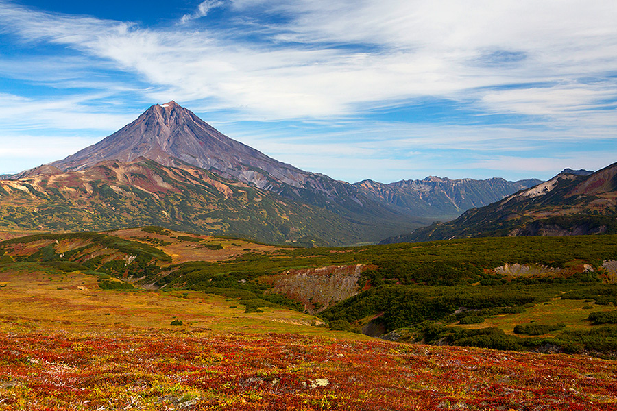
At 50 kilometers to the south-west, straight from Petropavlovsk-Kamchatsky, towers over Avachinskaya Bay, the Viluchik Volcano, surprisingly correct in form, as it is called local. In winter, the Vilyuchinsky volcano has a dazzling white cap and is an adornment of the bay panorama. This is a favorite resting place of snowboarders, it is suitable for skiing and snowmobiling. His correct cone is clearly visible from the city. The height of the Vilyuchinsky volcano is 2175 meters above sea level. On three sides, it is surrounded by the valleys of the Vilyucha, Paratunka and Bolshaya Sarannaya rivers.
Correct volcano
The top of the Vilyuchinsky volcano has a cut from the north side, where a small crater is located. Deep and almost even barrancos are almost completely filled with ice. In the past, fumaroles gave the lower part of the volcano a variegated appearance. The photo of the Vilyuchinsky volcano is striking in its beauty, which in 1996 was marked by UNESCO by inscribing it on the list of World Natural and Cultural Heritage sites in the category “Kamchatka Volcanoes”.
Extinct giant
Vilyuchinsky is considered an extinct stratovolcano, the eruption of which was 7,000 years ago. And although today it is not marked by seismic activity, but gas-vapor emissions have been repeatedly recorded at its top. Climbers who visited the top, talk about the smell of hydrogen sulfide. On the eastern side of the volcano there are numerous hot springs, and in the lower part there is a waterfall of the same name, about 40 meters high. From the north of the foot - cones and domes of slag and lava. Among them are lava and Topolovoe, which are rich in fish and interesting for anglers. 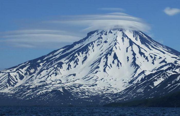
Tourist object
Vilyuchinsky volcano is part of the park and is a popular place to relax. The Topolovoye and Zelene lakes at the foot and the well-developed infrastructure of the Termalny settlement make it possible to go skiing, snowboarding and snowmobiles. Ice winter and summer fishing will delight lovers. And hot springs, which can be reached on foot, are considered to be among the most optimal wild sources in terms of accessibility.
Scenic Pass
Favorite walking route. Vilyuchinsky pass transition opens magnificent views. Its height in some places reaches 1 km above sea level. This winding road offers views of the Mutnovsky Plateau on the south side and the Vilyuchik volcano in the east. After the pass, tourists enter the valley, where the Vilyucha river and the Silent stream flow into the Vilyuchinsky bay. 
Extreme Vilyuchika
Extreme freeride and backcountry attract tourists. There are no lifts, and delivery to the top by helicopter or snowmobile only adds adrenaline sensations. Climbing the ascent of the volcano to a small height can even beginners. The route runs along the trail on the south-western slope. Climbing becomes quite difficult when the steepness of the slope reaches 35 degrees and requires special preparation and reliable equipment. Several classified routes of categories of complexity from 1B to 2B lead to the top.
Selle 1981
Typhoon "Elsa", which that year brought down its power of torrential rains around the world, hooked on Kamchatka. Rain streams washed away the slope and formed powerful mudflows. Nearby residents and residents of Petropavlovsk-Kamchatsky heard the roar from the peaks. A storm warning was announced. Then they died in three climbers who were returning from the ascent to the volcano. Their car just took the mudflow, as the only surviving participant told. 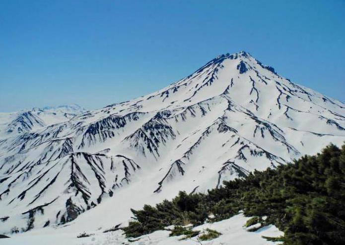
The tragedy of 2017
Volcano has always been avalanche. The relevant services conduct observations and warn tourists about the possibility of avalanches. That tragic avalanche of the Vilyuchinsky volcano, the photo and video of which was spread by the media, occurred on April 9. At that moment on the slope there were about 40 tourists who saw 2 people disappear in the snow mass on the northern slope. Lack of communication has delayed search operations. Witnesses had to get to the base to call for help. 40 units of equipment and more than 100 rescuers took part in the rescue of the victims. The bodies of the father and child were found by the end of the day on April 10 at a depth of 8 meters, which did not give a chance for survival. According to the accident investigation commission, an avalanche on the northern slope of the Vilyuchinsky volcano could not be provoked by the dead themselves while riding a snowmobile. They were fifth in the column of snowmobiles, and the previous four passed a fairly narrow stretch of the route in normal mode. There were no dead and rescue work was carried out with probes over the entire area of the avalanche. The avalanche most likely caused temperature drops, because it was warm on that tragic day. 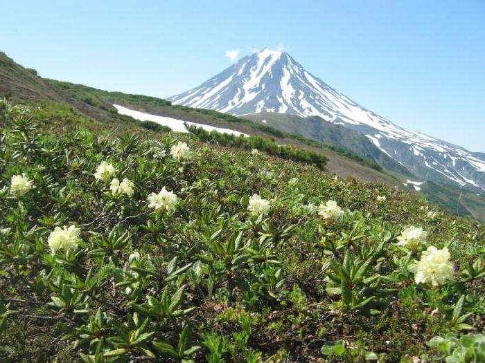
Avalanche zone
Every year, the EMERCOM of Russia in the Kamchatka Territory announces an avalanche danger in the mountainous areas of the Paratunka River Basin, and the Vilyuchinsky, Koryaksky, Avachinsky, Kozelsky and Klyuchevskaya volcanoes volcanoes. Tourists, hunters, lovers of extreme sports are warned of the danger, and they are encouraged to refrain from hiking in the mountains. But there are always people who neglect the safety rules. So, in 2010, during the period of avalanche danger, a teenager died while riding a snowboard on the northern slope of a volcano. And in February 2017, two people fell under an avalanche - a German citizen and a Russian tourist. They were skiing in a group of 18 people and were hit by a sudden avalanche. Unfortunately, the life of a 40-year-old German tourist could not be saved. 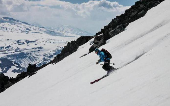
What to do when avalanches come down
Going to the mountains to ski, especially in avalanche areas, you must adhere to the following rules:
- Do not go out into the mountains if avalanche danger is declared.
- If the avalanche comes down high, use the opportunity to leave the route.
- If it is impossible to escape from the avalanche, take a horizontal position and orient the body in the direction of movement of the snow mass.
- If you find yourself in an avalanche, close your nose and mouth, and then swimming your way to the edge of the avalanche. It is necessary to breathe shallowly.
- Do not panic - you are looking for!
In conclusion, I would like to say the following. Even from the window you can fall out, but the likelihood of such a fall increases many times if you stand on a stool or window sill. Take care of your health and life, do not risk in vain, follow the rules of safety - and the memories of the rest will delight you with the rest of your life.
The Vilyuchinsky Volcano (Kamchatka Territory, not far from Petropavlovsk-Kamchatsky) rises above sea level by more than 2000 m. It has the shape of a regular cone and is visible from afar, which attracts many tourists. Most of them admire the volcano from the outside, take walks at its foot and take pictures of magnificent views that are not considered here. And only the most experienced skiers know how interesting Vilyuchinsky is for heli-skiing - one of the most extreme freeride varieties requiring good preparation and pristine snow slopes. It is impossible to get to the top of the volcano on the ski lifts, only on foot or on snowmobiles, and even better - by helicopter. Fans of heli-skiing unite in groups and rent a helicopter, which disembarks them at the starting point. For descent, several most suitable slopes of the volcano and the neighboring mountain ranges are used, the longest descent has a length of about 6 km. After skiing, skiers and snowboarders can go to the Upper Vilyuchinsky or Nizhne-Paratunsky thermal springs, where there are locker rooms and an opportunity to rest.
When to come
The slopes of Vilyuchinsky are covered with snow all year round. In summer, its quantity decreases, giving life to the Vilyuchinsky waterfall on the northwestern slope of the volcano. At the same time, it is in the summer - in May-July - it becomes easier to climb on the slopes of the volcano on foot in order to go down there on skis or snowboard. Tourist groups get to the most persistent glaciers and snow-covered slopes, where you can ride a little in shorts. Least of all snow in August, this month is not recommended for skiing. But in winter there is a place even for cross-country skiing. Since the volcano is located in the southern part of the Kamchatka Peninsula, you should not be afraid of severe frosts (in winter the temperature rarely drops below -10 degrees Celsius), but often there is heavy rainfall, especially in the autumn months.
How to get there
Petropavlovsk-Kamchatsky has air and sea communication with many Russian cities. From it to the volcano in a straight line - about 25 km, in fact, it is necessary to make a rather long journey, since Vilyuchinsky is located on the edge of Avacha Bay opposite Petropavlovsk. Organized tourist groups take him to the bus and take them back in the same way. You will have to drive yourself (best of all, an off-road vehicle), first - to the village of Thermalny, then take the road to the Mutnovskaya geothermal power station, and then another 15 minutes along the path to the glacier, which does not melt all summer. You can get to Thermal (or neighboring Paratunka) by bus, but then you have to change to a car, since public transport does not go to the volcano.
Where to stay
If the purpose of the trip is Vilyuchinsky, then it is worth to settle as close as possible to it. The best option Paratunka village will become - near it sources of therapeutic thermal waters are discovered (Lower-Paratunsky sources), on the basis of which a large balneological resort with several hotels and recreation centers was created. If you are interested in a wider acquaintance with the south of Kamchatka, then it is better to stay in one of the hotels in Petropavlovsk-Kamchatsky, where there are more opportunities for organizing all kinds of excursions.
Related publications
-
 Avachinsky Volcano (Avachinskaya Sopka, Avacha, Avachinsky Volcano, Avacha Volcano, Avachinskaya Sopka)
March 31st, 2013 Today we had an early ascent, as climbing Avachinsky takes a lot of time from untrained tourists ....
-
 Mountains and ridges of Kamchatka
The Kamchatka Peninsula is the most unique mountain region in Russia. Kamchatka Territory is located in the north-east of Russia. Occupies territory ...